

United States Geographic Information System (GIS)Market Summary
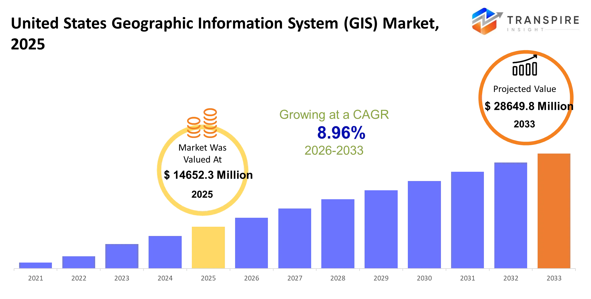
As per Transpire Insight Analysis the United States Geographic Information System (GIS) Market size is estimated at USD 14652.3 Million in 2025 and is anticipated to reach USD 28649.8 Million by 2033, growing at a CAGR of 8.96% from 2026 to 2033.
The United States Geographic Information System (GIS) Market, it’s basically helping organizations somehow turn location data into useful choices, like for planning utility networks and transportation corridors, all the way to managing land infrastructure, public safety needs, and environmental assets. In the last 3–5 years the market kind of been sliding away from the older desktop mapping model, toward cloud platforms, location intelligence with real-time data, mobile GIS, and AI assisted spatial analytics. Cloud infrastructure growth has made GIS tools easier to launch across dispersed teams, while newer sensors , satellite imagery, plus connected devices have bumped up the total volume of geospatial data you can actually use. At the same time , harsh weather events resilience programs for infrastructure and even supply-chain interruptions have pushed government agencies and businesses into faster geographic analysis. And when companies sort of connect GIS with enterprise systems, digital twins, and predictive analytics, adoption stops being only a niche circle of cartography specialists, and it starts showing up in more everyday operational routines, which then kind of opens the door for more software platform, data, and managed-service revenue.
United States Geographic Information System (GIS)Market Size & Forecast:
- United States Geographic Information System (GIS) Market Market Size 2025: USD 14652.3 Million
- Expected Market Value 2033: USD 28649.8 Million
- Forecast CAGR: 8.96%
- Leading region in 2025: Western United States
- Fastest Growing region: Southern United States
- Key Profile: Esri, Hexagon AB, Autodesk Inc., Bentley Systems, Trimble Inc., SuperMap Software, Pitney Bowes, Oracle Corporation, IBM Corporation, Precisely, Maxar Technologies, HERE Technologies, TomTom NV, Google LLC, Safe Software
Key Market Insights
- The United States Geographic Information System (GIS) Market, will expand from USD 14.65 billion in 2025 to about USD 28.65 billion by 2033.
- A lot of momentum has built up in Cloud GIS since 2020, because orgs moved spatial workloads from lone desktop setups toward shared enterprise platforms, kind of more scalable, and yes a little more connected than before.
- After 2023 AI-enabled spatial analytics started catching real traction, enabling automation for image classification, asset discovery, routing decisions, and geographic forecasting.
- Government agencies still look like the biggest buyers, since GIS supports infrastructure planning, emergency reaction, zoning, public services ,and environmental monitoring.
- Utilities are starting to lean into real-time GIS along with IoT sensors, and that kind of helps with network visibility, asset checks, outage handling, and even field service coordination when crews are out there moving around.
- Mobile GIS has also grown quite a bit, because field teams are capturing location based details via smartphones, tablets, GNSS receivers, and other connected sensing tools.
- Western states continue to show strong GIS usage, mainly because technology companies, infrastructure operators, environmental programs, and large public agencies keep creating heavy spatial-data needs.
- Southern states, on the other hand, appear like the faster-growth opening, with population growth, construction activity ,transportation spending, utilities expansion, and disaster planning all increasing geospatial workloads.
- Also, digital-twin initiatives are pushing GIS past “just mapping” by tying geographic information to infrastructure models, sensor streams, engineering records, and operational systems.
- Meanwhile, leading vendors are strengthening their competitive edge through cloud platforms, artificial intelligence features, satellite imagery, location intelligence, interoperability efforts, partnerships and industry-focused, specialized applications.
What are the Key Drivers, Restraints, and Opportunities in the United States Geographic Information System (GIS) Market?
Driver: The strongest growth force is that shift from static mapping toward cloud based spatial intelligence , kind of like a gradual drift. Since 2020, distributed work connected infrastructure, and bigger volumes of sensor and satellite information have pushed organizations to centralize geographic information on scalable platforms. Cloud deployment reduces the reliance on dedicated local infrastructure and lets government departments utilities engineering teams, and field workers pull from shared datasets. When GIS integrates with enterprise resource planning asset management, IoT and analytics systems it stops acting like a niche mapping tool, and more like an operational instrument. This expanded function tends to lift software subscriptions, data services , implementation work and even managed service revenue.
Restraint: Still, high implementation complexity is a structural obstacle that doesn’t really go away. Large organizations often keep legacy databases, incompatible coordinate frameworks, aging applications, and geographic datasets that are split across different places. Migration means data cleansing and unifying systems, plus cybersecurity guardrails, employee training, and specialized technical competence. All of that stretches deployment timelines, and it can postpone modernization budgets, especially for smaller municipalities and organizations that have limited IT bandwidth.
Opportunity: AI enabled geospatial intelligence gives a meaningful growth window. Computer vision can study satellite and aerial imagery to detect buildings, road conditions, vegetation shifts, land use changes, and other infrastructure signals. Meanwhile, machine learning can surface spatial patterns across massive collections of data. Digital twin investment is another angle, as cities transportation agencies utilities and infrastructure businesses connect 3D models with live geographic data, not just for display but for ongoing decisions.
What Has the Impact of Artificial Intelligence Been on the United States Geographic Information System (GIS) Market?
Artificial intelligence is kind of shifting GIS from something that is mostly analytical mapping, into a more automated decision support vibe system. Machine learning models can sort satellite and aerial imagery, spot buildings and roads, notice land use changes, pull out geographic features, and also help organize huge amounts of messy unstructured spatial information. Computer vision meanwhile backs infrastructure inspection, it can recognize pavement deterioration, vegetation encroachment, damaged assets, and construction changes seen in imagery. For utilities, AI-supported GIS can merge asset locations with weather context, sensor readings, and past failures, to better forecast outages and schedule maintenance—more or less. Transportation agencies can even run machine learning on traffic patterns, road conditions, mobility data, and routing details to help with network planning and operational tuning.
There’s also advanced analytics, which improves disaster management by bringing geographic information together with weather, flood, wildfire, and population datasets, so risk assessment becomes faster, not slower. Generative AI is starting to simplify GIS workflows too, it can help with natural language questions, automated map creation, data interpretation, and spatial-analysis support. Still, adoption can stumble because integration costs are high, data quality stays inconsistent, legacy platforms don’t always talk well together, and there’s a need for specialized expertise. AI performance also leans a lot on current well-structured geospatial datasets, so data governance becomes a critical requirement, for reliable deployment and not just nice demos.
Key Market Trends
Teams and centralized spatial-data access , kind of. AI-assisted mapping expanded after 2023, letting people classify imagery faster and do feature extraction asset detection, plus geographic change analysis , more or less. Mobile GIS adoption has gone up , because field personnel now routinely collect infrastructure and asset information using connected smartphones or tablets, usually on the spot.
Utilities are also linking GIS with IoT sensors to boost network visibility and make outage response smoother, strengthen inspection workflows, and improve asset maintenance practices. Digital twins have moved past small pilot efforts and into actual infrastructure use cases, where 3D models geographic data sensors and engineering information all get tied together, not neatly sometimes. Severe weather events, like floods and wildfires, have made GIS use feel more urgent for flood mapping, wildfire assessment emergency planning evacuation analysis, and infrastructure resilience.
In the Southern U.S. markets there is noticeable momentum too, as population growth and construction investment keep rising and push demand for land plus infrastructure intelligence. Satellite imagery and remote sensing are now easier to get, so geospatial analysis expands across agriculture environmental monitoring defense construction, and insurance.
GIS vendors are competing more through AI, cloud integration, interoperability, real-time analytics, and specialized solutions rather than just standalone mapping features. Enterprise buyers are increasingly expecting GIS platforms to connect with ERP, CRM, asset management IoT, engineering tools, and business intelligence environments, like it should be assumed.
United States Geographic Information System (GIS) Market Segmentation
By Component:
Software is kinda the core tech layer for geographic data handling, spatial analysis stuff, mapping and visualization , plus location based decision-making. Software makes routine mapping easier, and also helps with the more advanced analytics side, while GIS Platforms give a more centralized setting for enterprise people. Spatial Analytics Tools help spot patterns and do geographic modelling, and Remote Sensing Software is the thing that actually processes satellite and aerial imagery. Mapping Software still matters for visuals, navigation, planning and even field operations, pretty continuously. Location Intelligence Solutions basically connect geographic information with business data so organizations can make strategic calls. Geospatial Databases organize big spatial datasets and let enterprise applications run smoothly. Hardware, on the other hand, includes GNSS devices, servers, mobile gear, sensors, and specialized data-capture systems. Services cover consulting, implementation, integration, training, maintenance and managed operations. Others exist too, for specialized geographic workflows, that can be pretty niche.
Cloud-connected software, and analytics services , will keep growing in importance as organizations want scalable access to geographic information. Hardware needs will stay tied to field collection, surveying, remote sensing, and infrastructure monitoring. Services will also back up migration, integration, data management, and system customization, especially across large public-sector and infrastructure programs. Others will then handle more specific needs across mapping, visualization, geocoding and spatial-data processing.
By Deployment:
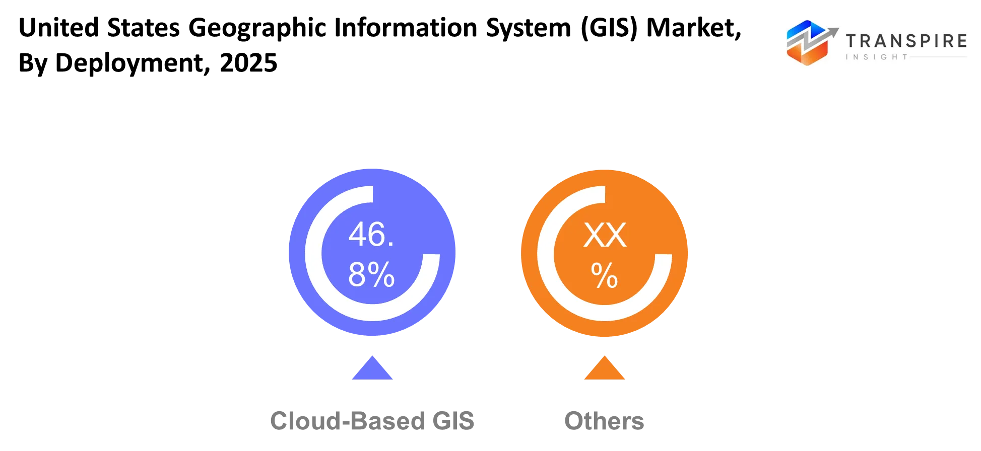
Cloud- based deployment helps with centralized access to geographic data, gives scalable computing power, and makes it easier for teams to collaborate even when they’re spread out in different places. On-premise deployment still matters for organizations that need direct control of their infrastructure, careful sensitive-data handling , or tight integration with systems already inside the company. Hybrid Cloud is basically local infrastructure plus cloud resources , for organizations shifting from legacy GIS architecture, step by step. SaaS offers subscription based access to GIS applications, and it cuts down the need for heavy upfront infrastructure. Private Cloud gives you a more controlled environment, while Public Cloud leans into scalability and wider accessibility. Edge GIS takes a selected slice of processing and pushes it closer to field devices and other connected assets. Mobile GIS lets field teams gather, revise, and retrieve location information using mobile devices. Others, of course, cover niche or specialized deployment needs.
Cloud-based and SaaS approaches will keep on being adopted because they’re flexible with capacity, support remote access, allow centralized updates, and let people buy through subscription procurement. On-premise and private-cloud patterns will stay relevant in government, defense, utilities, and in other groups that manage sensitive geographic information. Hybrid deployment can help with gradual modernization, especially when older databases cannot move right away into public cloud environments. Edge GIS along with Mobile GIS will make field operations stronger, by lowering reliance on continuous centralized processing and enabling faster geographic-data capture.
By Application:
Urban Planning uses GIS for zoning, land use analysis, infrastructure planning, population mapping and development assessment. Transportation applications also rely on GIS for route planning, traffic analysis, road management, public transit planning , and ongoing infrastructure monitoring. Agriculture in turn uses spatial information for crop monitoring, field analysis, irrigation planning, and resource management in a more careful way. Utilities apply GIS to electricity, water, gas, and telecommunications networks, mostly for asset mapping and maintenance tasks, a bit like keeping everything sorted in place. Defense & Intelligence lean on geographic information for terrain analysis , surveillance, mission planning, and situational awareness, while people tend to forget how much this changes decisions fast.
Environmental Monitoring is used to help with ecosystem analysis, plus pollution tracking, conservation, and climate related assessments as well, not only that. Disaster Management can also assist in hazard mapping, emergency responses, evacuation planning, and even recovery operations too, it all kind of overlaps in practice.
Land Management supports property records, cadastral mapping, development control, and resource planning for local areas. Smart Cities connect GIS with sensors, infrastructure systems, mobility data, and digital twin platforms, with the aim to improve urban operations, and honestly it’s more than dashboards.
Other examples include healthcare planning, insurance analysis, retail location planning, telecommunications coverage, and commercial site selection, all of that. Urban planning, utilities, transportation, and disaster management will stay key application areas because geographic analysis directly supports infrastructure decisions and public services. Smart city and environmental applications will gain more traction, because cities keep connecting real time data with spatial data , and then using it before it gets stale platforms.
By End User:
Government still remains this big GIS user for land administration, public infrastructure, planning, emergency response, environmental programs, and public-service management , kind of always. Defense relies on geographic intelligence for terrain assessment, surveillance, operational planning and national-security use cases , not just one thing. Utilities depend on spatial databases for network mapping, asset management, inspections and maintenance, day to day. Transportation organizations use GIS for road networks, transit planning , traffic analysis, and infrastructure management. Agriculture applies geographic information to crop monitoring, land analysis, irrigation, and resource allocation. Construction uses GIS for site analysis, surveying, infrastructure planning and project coordination. Telecommunications applies spatial analytics for network planning, coverage analysis, and infrastructure deployment.
Oil and Gas organizations use GIS for pipeline mapping, facility management, exploration support, and environmental monitoring. Healthcare applications include facility planning, population analysis, disease mapping, and service-access assessment. Others cover retail, insurance, real estate, logistics, education, and environmental organizations in general. Government and utilities will keep producing substantial GIS requirements because big asset networks need ongoing geographic-data management. Telecommunications, construction, transportation, and infrastructure operators will add more growth through network expansion, asset digitization, and location-based planning, so basically it keeps going.
By Enterprise Size:
Large Enterprises use GIS in sort of enterprise-wide asset management , infrastructure planning, location intelligence, operational analytics , and they integrate it with corporate systems, kind of seamless. SMEs increasingly adopt cloud-based GIS because subscription models reduces infrastructure requirements a bit , and it also gives access to more advanced spatial capabilities. Public Sector Organizations use geographic information for planning, land management, emergency services, transportation and infrastructure programs too, yes. Research Institutes apply GIS to environmental studies, geographic modeling, climate research, public health , and scientific analysis. Municipal Authorities use spatial platforms for zoning, utilities, public works , emergency planning, and local infrastructure management.
Infrastructure Companies rely on GIS for project planning, asset monitoring, surveying, construction coordination , and maintenance. Educational Institutions use geographic platforms for teaching, research, campus planning , and spatial data analysis. Others include nonprofit organizations, consulting firms, commercial property groups, and specialized service providers. Large enterprises and public-sector organizations will retain substantial spending because complex infrastructure needs centralized geographic systems. SMEs will gain greater access through SaaS, and cloud based offerings , while municipal authorities and infrastructure companies will keep adopting GIS for asset modernization and digital planning, honestly.
What are the Key Use Cases Driving the United States Geographic Information System (GIS) Market?
Urban planning and infrastructure management count as big GIS use cases, because government agencies and municipal authorities need solid geographic intelligence, for things like zoning , land development, transport corridors, utilities, and public assets, basically everything that sits on the map. In practice, GIS links property data with demographic records, infrastructure layers, and environmental information, so planners can compare development choices ahead of time, before they commit the money or the time, to a specific plan.
Meanwhile utilities and transportation organizations are pushing GIS further into asset management, network planning, maintenance scheduling, traffic analysis, and even field operations. Electricity, water, telecommunications, roads, and transit operators rely on location intelligence to coordinate dispersed infrastructure, and to decide what gets fixed first. Construction firms also lean on GIS for site assessment, surveying, project coordination, and infrastructure planning, because having spatial context saves a lot of rework.
More recent directions include AI- aided satellite-image interpretation, digital twin environments, predictive infrastructure upkeep, and real time disaster situational awareness. Smart-city efforts will fuse GIS with IoT sensing, mobility signals, and 3D modeling, and that mix should open up stronger chances for real-time operational decisions, through 2033.
|
Report Metrics |
Details |
|
Market size value in 2025 |
USD 14652.3 Million |
|
Market size value in 2026 |
USD 15714.6 Million |
|
Revenue forecast in 2033 |
USD 28649.8 Million |
|
Growth rate |
CAGR of 8.96% from 2026 to 2033 |
|
Base year |
2025 |
|
Historical data |
2021 - 2024 |
|
Forecast period |
2026 - 2033 |
|
Report coverage |
Revenue forecast, competitive landscape, growth factors, and trends |
|
Regional scope |
United States; Canada; Mexico; United Kingdom; Germany; France; Italy; Spain; Denmark; Sweden; Norway; China; Japan; India; Australia; South Korea; Thailand; Brazil; Argentina; South Africa; Saudi Arabia; United Arab Emirates |
|
Key company profiled |
Esri, Hexagon AB, Autodesk Inc., Bentley Systems, Trimble Inc., SuperMap Software, Pitney Bowes, Oracle Corporation, IBM Corporation, Precisely, Maxar Technologies, HERE Technologies, TomTom NV, Google LLC, Safe Software . |
|
Customization scope |
Free report customization (country, regional & segment scope). Avail customized purchase options to meet your exact research needs. |
|
Report Segmentation |
By Component (Software, Hardware, Services, GIS Platforms, Spatial Analytics Tools, Remote Sensing Software, Mapping Software, Location Intelligence Solutions, Geospatial Databases, Others); By Deployment (Cloud-Based, On-Premise, Hybrid Cloud, SaaS, Private Cloud, Public Cloud, Edge GIS, Mobile GIS, Others); By Application (Urban Planning, Transportation, Agriculture, Utilities, Defense & Intelligence, Environmental Monitoring, Disaster Management, Land Management, Smart Cities, Others); By End User (Government, Defense, Utilities, Transportation, Agriculture, Construction, Telecommunications, Oil & Gas, Healthcare, Others); By Enterprise Size (Large Enterprises, SMEs, Public Sector Organizations, Research Institutes, Municipal Authorities, Infrastructure Companies, Educational Institutions, Others) |
Which Regions are Driving the United States Geographic Information System (GIS) Market Growth?
The Western United States still looks like the big dominant regional market , backed by California, Washington, Colorado, and a handful of other technology-heavy states where public-sector GIS programs really stay active along with advanced infrastructure work. This area kind of rides on a dense web of technology companies, engineering outfits, satellite-data providers, utilities, and government agencies, all of which keep producing more and more sophisticated geospatial workloads , not just once in a while. In particular California’s wildfire management, water planning, transportation programs, and climate-resilience efforts generate repeat needs for spatial analytics, remote sensing, and near-real-time cartography. Plus , strong adoption of newer tech helps Western organizations link GIS with cloud computing, AI, digital twins, and IoT systems sooner than markets that are less digitally mature.
The Northeastern United States has a more distinct growth profile, with demand bolstered by dense city development, aging infrastructure, transportation corridors, and heavy concentrations of government plus institutional activity. States like New York, Massachusetts, Pennsylvania, and New Jersey offer a steady customer base , because municipalities, utilities, transportation authorities , and engineering organizations need continuous asset mapping and ongoing infrastructure planning. And the high population density makes location intelligence kind of more valuable for transit optimization, land-use strategizing, emergency response , and utility coordination.
The Southern United States is positioned as the fastest-growing regional market , since migration patterns move people around, construction activity speeds up, industrial expansion expands , and infrastructure investments rise across the geography , which in turn increases the need for geographic-data projects.
Who are the Key Players in the United States Geographic Information System (GIS) Market and How Do They Compete?
In the United States GIS market competition is somewhat concentrated around the big platform players, but specialized companies are still fighting it out across imagery, location intelligence, infrastructure design, positioning , and spatial data management. Honestly the main contest moved, it used to be mostly about mapping basics, now its more about cloud scalability and AI assisted analysis, plus interoperability, real time data processing, digital twin efforts, and then those industry specific workflows. Buyers are also more likely to judge vendors by how well they can connect GIS with enterprise systems, instead of just buying standalone mapping software, you know.
Esri seems to hold its place using the wide ArcGIS ecosystem, a large partner web, and deep integration with government, utilities, infrastructure, and enterprise operations. It also leans on its work with Pix4D on real time terrestrial mapping, which makes the link between field capture and ArcGIS workflows stronger. Bentley Systems differentiates by focusing on infrastructure engineering, digital twins, and asset analytics, and its January 2026 acquisitions of Talon Aerolytics along with Pointivo added more AI driven inspection functions. Hexagon AB pulls together sensors, positioning, spatial intelligence, and industrial software so customers get a more direct pathway from data capture to operational analysis. Trimble competes with high precision positioning, field technology, construction workflows, and connected geospatial data, while Autodesk pushes harder through BIM and infrastructure design integration.
Company List
- Esri
- Hexagon AB
- Autodesk Inc.
- Bentley Systems
- Trimble Inc.
- SuperMap Software
- Pitney Bowes
- Oracle Corporation
- IBM Corporation
- Precisely
- Maxar Technologies
- HERE Technologies
- TomTom NV
- Google LLC
- Safe Software
Recent Development News
- "In January 2026, Bentley Systems announced acquisitions of Talon Aerolytics and Pointivo technology. The acquisitions strengthened Bentley's Asset Analytics portfolio by adding AI-powered inspection, machine-learning workflows, and digital-twin capabilities for infrastructure asset management.http://www.bentley.com/news/bentley-systems-acquires-talon-aerolytics-and-pointivo-technology-for-asset-analytics-leadership/ (Bentley Systems)."
- "In February 2026, Esri and Pix4D launched a real-time terrestrial mapping workflow. The collaboration connects Pix4Dcatch asset-capture capabilities with ArcGIS, improving the movement of field-generated 3D and geospatial information into GIS workflows.http://www.esri.com/about/newsroom/announcements/ (Esri)."
- "In March 2026, Esri and RoboGarden signed a strategic memorandum of understanding to advance geospatial and geomatics education. The agreement targets digital learning, academic collaboration, and workforce development, supporting the future availability of GIS skills across organizations and regions.http://www.esri.com/about/newsroom/announcements/esri-and-robogarden-sign-strategic-mou-to-advance-geospatial-and-geomatics-education (Esri)."
What Strategic Insights Define the Future of the United States Geographic Information System (GIS) Market?
The market is kind of structurally moving ,from mapping software toward an enterprise spatial-intelligence layer that links AI cloud platforms ,IoT satellite imagery ,digital twins and operational databases together. The core driver, if you want a simpler phrasing is turning location data into real time operational decisions, especially across infrastructure utilities transportation public safety and government. There is also a less obvious danger: vendor concentration combined with data and platform lock in, because organizations that end up building critical workflows around proprietary ecosystems, can end up paying larger relocation costs and having less room to negotiate. Another issue is fragmented data standards , which can quietly reduce the accuracy of AI models when teams try to blend imagery sensor streams legacy databases and third party datasets.
On the upside, there is an emerging opening for AI powered geospatial agents that can parse spatial questions, pick relevant datasets, conduct analyses and deliver decision ready outputs with minimal specialist involvement. Market players should focus on interoperable, cloud-native platforms, with strong APIs and open data standards, while they also assemble sector specific AI workflows. This pathway can lower the integration friction , widen the possible customer pool , and help vendors earn higher value recurring revenue as GIS gets embedded into operational systems, not just sitting there as a standalone mapping function.
United States Geographic Information System (GIS) Market Report Segmentation
By Component
- Software
- Hardware
- Services
- GIS Platforms
- Spatial Analytics Tools
- Remote Sensing Software
- Mapping Software
- Location Intelligence Solutions
- Geospatial Databases
- Others
By Deployment
- Cloud-Based
- On-Premise
- Hybrid Cloud
- SaaS
- Private Cloud
- Public Cloud
- Edge GIS
- Mobile GIS
- Others
By Application
- Urban Planning
- Transportation
- Agriculture
- Utilities
- Defense & Intelligence
- Environmental Monitoring
- Disaster Management
- Land Management
- Smart Cities
- Others
By End User
- Government
- Defense
- Utilities
- Transportation
- Agriculture
- Construction
- Telecommunications
- Oil & Gas
- Healthcare
- Others
By Enterprise Size
- Large Enterprises
- SMEs
- Public Sector Organizations
- Research Institutes
- Municipal Authorities
- Infrastructure Companies
- Educational Institutions
- Others
Frequently Asked Questions
Find quick answers to common questions.
The expected United States Geographic Information System (GIS) Market size for the market will be USD 28649.8 Million in 2033.
Key segments for the United States Geographic Information System (GIS) Market are By Component (Software, Hardware, Services, GIS Platforms, Spatial Analytics Tools, Remote Sensing Software, Mapping Software, Location Intelligence Solutions, Geospatial Databases, Others); By Deployment (Cloud-Based, On-Premise, Hybrid Cloud, SaaS, Private Cloud, Public Cloud, Edge GIS, Mobile GIS, Others); By Application (Urban Planning, Transportation, Agriculture, Utilities, Defense & Intelligence, Environmental Monitoring, Disaster Management, Land Management, Smart Cities, Others); By End User (Government, Defense, Utilities, Transportation, Agriculture, Construction, Telecommunications, Oil & Gas, Healthcare, Others); By Enterprise Size (Large Enterprises, SMEs, Public Sector Organizations, Research Institutes, Municipal Authorities, Infrastructure Companies, Educational Institutions, Others).
Major United States Geographic Information System (GIS) Market players are Esri, Hexagon AB, Autodesk Inc., Bentley Systems, Trimble Inc., SuperMap Software, Pitney Bowes, Oracle Corporation, IBM Corporation, Precisely, Maxar Technologies, HERE Technologies, TomTom NV, Google LLC, Safe Software.
The United States Geographic Information System (GIS) Market size is USD 14652.3 Million in 2025.
The United States Geographic Information System (GIS) Market CAGR is 8.96% from 2026 to 2033.
- Esri
- Hexagon AB
- Autodesk Inc.
- Bentley Systems
- Trimble Inc.
- SuperMap Software
- Pitney Bowes
- Oracle Corporation
- IBM Corporation
- Precisely
- Maxar Technologies
- HERE Technologies
- TomTom NV
- Google LLC
- Safe Software
About the Authors

Mayur Shinde
I am Mayur Shinde, a Senior Research Analyst at Transpire Insight, specializing in the Automotive & Transportation and Information & Communication Technology (ICT) Industry. My work focuses on analyzing emerging market trends, technological advancements, competitive landscapes, and industry developments to deliver accurate, data-driven insights. I am passionate about transforming complex market information into clear, actionable content that helps businesses, professionals, and decision-makers stay informed and make confident strategic decisions.

Chakradhar Khansole
Chakradhar serves as the Research Director at Transpire Insight, bringing over 8 years of experience in technology, innovation, and strategic market intelligence. He specializes in transforming complex market data into actionable business insights that enable organizations to make informed, growth-oriented decisions. Recognized for his strategic vision and analytical expertise, Chakradhar leads high-impact research initiatives, delivering comprehensive market assessments, competitive intelligence, and forward-looking industry analysis.
Recently Published Reports
-
Apr 2026
3D Optical Profiler Market
3D Optical Profiler Market Size, Share & Analysis Report By Type (Desktop 3D Optical Profiler, and Portable 3D Optical Profiler), By Technology (Confocal Technology, and White Light Interference), By End-Use Industry (Manufacturing, Research Institutions, Automotive, Aerospace and Defense, Medical Devices, and Other), and Geography (North America, Europe, Asia-Pacific, Middle East and Africa, South and Central America), 2021 - 2031
-
Apr 2026
Depth Sensor Market
Depth Sensor Market Size, Share & Analysis Report By Type (Infrared Depth Sensors, Time-of-Flight (ToF) Sensors, Stereo Vision Sensors, Structured Light Sensors, Ultrasonic Depth Sensors), By Application (Automotive, Robotics, Gaming, Consumer Electronics, Industrial Automation, Healthcare, Security & Surveillance, Others), By End Users (Automotive Manufacturers, Consumer Electronics Companies, Healthcare Providers, Industrial Companies, Security Agencies, Gaming Companies, Robotics Companies, Others), and Geography (North America, Europe, Asia-Pacific, Middle East and Africa, South and Central America), 2021 – 2031
-
Apr 2026
Digital Manufacturing Market
Digital Manufacturing Market Size, Share & Analysis Report By Component (Hardware, Software, and Services), By Technology (Robotics, 3D Printing, Internet of Things (IoT), and Others), By Application (Automotive and Transportation, Aerospace and Defense, Consumer Electronics, Industrial Machinery, and Others), By Process Type (Computer-Based Designing, Computer-Based Simulation, Computer 3D Visualization, Analytics, and Others), and Geography (North America, Europe, Asia-Pacific, Middle East and Africa, South and Central America), 2021 – 2031
-
Apr 2026
Digital Visa Services Market
Digital Visa Services Market Size, Share & Analysis Report By Type (Individual Travelers, Group Travelers), By Application (Tourism, Business Travel, Others), and Geography (North America, Europe, Asia-Pacific, Middle East and Africa, South and Central America), 2021 – 2031