
Asia Pacific Geospatial Analytics Market Size & Forecast:
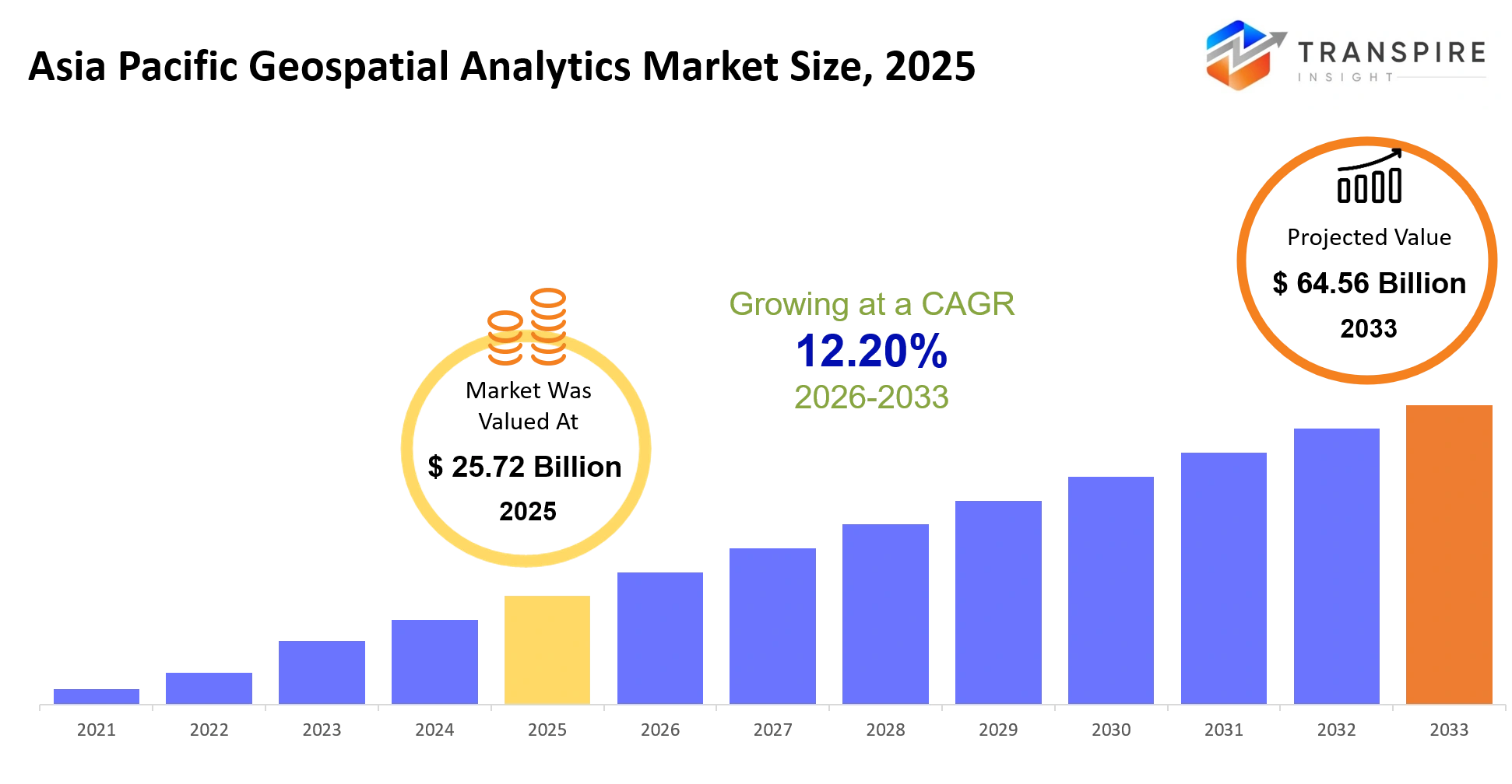
- Asia Pacific Geospatial Analytics Market Size 2025: USD 25.72 Billion
- Asia Pacific Geospatial Analytics Market Size 2033: USD 64.56 Billion
- Asia Pacific Geospatial Analytics Market CAGR: 12.20%
- Asia Pacific Geospatial Analytics Market Segments: By Component (Software, Services, Data, GIS Platforms, Analytics Tools, Visualization Tools, Cloud Platforms, Others); By Technology (Remote Sensing, GIS, GPS, LiDAR, UAV Mapping, Spatial Analytics, Geocoding, Others); By Application (Urban Planning, Defense, Agriculture, Transportation, Utilities, Environmental Monitoring, Others); By End User (Government, BFSI, Retail, Telecom, Healthcare, Agriculture, Others).
To learn more about this report,  Download Free Sample Report
Asia Pacific Geospatial Analytics Market Summary
The Asia Pacific Geospatial Analytics Market was valued at USD 25.72 Billion in 2025. It is forecast to reach USD 64.56 Billion by 2033. That is a CAGR of 12.20% over the period.
Asia Pacific geospatial analytics is used to turn satellite imagery, GPS feeds, and sensor information into operational calls for shipping operators, port authorities, mining firms, and urban infrastructure planners. It kind of helps people see vessel movement more clearly, anticipate gridlock, keep tabs on assets, and evaluate environmental or terrain risks in real time , too.
Over the last three to five years, the market kind of moved away from static GIS mapping, toward cloud-native, AI-enabled geospatial intelligence platforms that ingest continuous data streams. That shift has been pushed along by supply chain shocks during the COVID-19 period, which showed weaknesses in maritime and logistics networks , plus the more familiar climate related disruptions like floods and typhoons across Southeast Asia. So, in the end, enterprises and governments are putting money into predictive routing , resilience planning , and real time monitoring setups. This is speeding up adoption and expanding commercial uses in transportation, energy , and public sector infrastructure.
Key Market Insights
- China is sitting at almost 34% in 2025, sort of held up by big scale smart city rollout and the continued expansion of satellite imaging infrastructure, kinda advanced stuff.
- India, meanwhile is the quickest expanding market all the way through 2032, driven by digital public foundations and a very rapid uptake of location intelligence platforms.
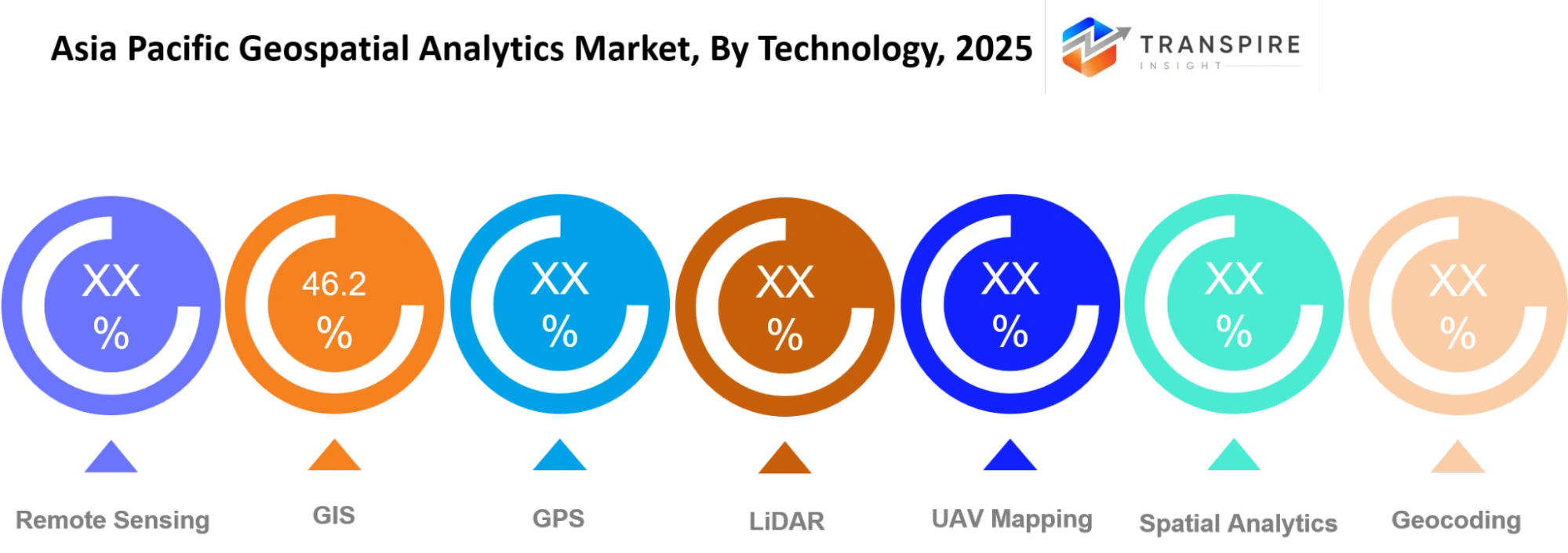
- On the software side, platforms take the lead in the Asia Pacific Geospatial Analytics Market with about 46% share, and it’s mainly pushed by enterprise GIS along with cloud native tools.
- The services part lands in second place, not surprising really, because companies keep asking for more integration work, consulting guidance, and spatial data administration support.
- Cloud based geospatial analytics is also moving the quickest, since enterprises are gradually switching toward scalable, real time data processing models, more or less.
- In the realm of transportation and logistics, these lead applications with something like a 38% share , especially across maritime routing and port optimization systems.
- For defense and disaster management, it’s actually the fastest-growing application stream, backed by more frequent climate related disruptions and also border monitoring requirements.
- Government agencies stay in front with about 40% share , mainly because of heavy investments in smart cities and nationwide mapping programs.
- Then there’s energy and utilities , which are the fastest-growing end user group, leaning into geospatial intelligence for grid optimization and asset watch.
What are the Key Drivers, Restraints, and Opportunities in the Asia Pacific Geospatial Analytics Market?
The primary driver of the Asia Pacific Geospatial Analytics market is the fast and a lot less stop-start integration of real-time spatial intelligence into logistics, urban planning, and maritime operations. In practice , governments and enterprises are rolling out satellite-enabled monitoring setups and cloud GIS platforms, to cut operational friction across transportation networks and improve disaster response. This change is kind of pushing revenue forward too, because organizations are moving away from static map tools, toward predictive, AI-enhanced geospatial ecosystems that actually help with ongoing decision-making.
A big restraint is the integration complexity, especially when legacy infrastructure has to “shake hands” with modern geospatial analytics platforms. A lot of enterprises still depend on fragmented data systems, and those systems are often not cloud-compatible, so modernization becomes expensive and slower. The timelines get delayed, and adoption drops, most noticeable among mid-sized operators and public agencies that have tight digital budgets. In the end this structural issue tends to quiet down near-term monetization, not just a little, but consistently.
The most promising opportunity sits in AI-powered digital twin ecosystems for smart cities and maritime corridors. Countries like India, Singapore, and China are putting money into high-resolution spatial modeling for infrastructure durability and port optimization. These efforts make simulation-based planning possible, for congestion, emissions, and disaster scenarios, and they open new revenue avenues via subscription-style analytics, plus government-private data partnerships.
What Has the Impact of Artificial Intelligence Been on the Asia Pacific Geospatial Analytics Market?
Artificial intelligence is basically remaking marine and industrial geospatial analytics in a way that sort of pushes automation through spatial data processing, and even operational control systems. In shipping plus port operations , AI algorithms now dig through satellite feeds , AIS vessel data, and various environmental signals, to drive route optimization, berth allocation, and scrubber performance monitoring inside emission control frameworks. The effect is less manual checking and better compliance accuracy with exhaust gas cleaning systems.
Predictive analytics, powered by machine learning models, is getting used more and more to anticipate equipment failures, tune fuel consumption, and estimate emissions while conditions change. Because of this, fleet operators can squeeze higher efficiency, sometimes around 8–12% and also trim unplanned downtime by spotting maintenance needs early, especially in propulsion and exhaust related hardware.
On the operational side, AI driven geospatial platforms help reduce decision latency , meaning operators can make near real time adjustments to navigation routes when weather goes bad, or when ports get congested. That tends to boost uptime reliability, and it generally lowers operational costs across wider maritime logistics networks.
Still, adoption has limits, mostly due to scarce high quality maritime training data and spotty satellite connectivity out in remote ocean areas. Those missing pieces weaken model accuracy in real world settings, especially for predictive maintenance and emissions forecasting, where exactness matters a lot for compliance and operational safety.
Key Market Trends
- Enterprises kinda moved away from periodic GIS reporting in 2020 toward more or less continuous, real-time geospatial streaming with cloud-native analytics platforms, and it stuck around.
- From 2021 to 2025, AI integration climbed up a lot—like over 60% of fresh deployments that put in predictive spatial modeling tools, embedded them pretty directly.
- Port authorities, since 2022, shifted from manual vessel tracking , to automated AIS satellite fusion systems, used for congestion handling and berth optimization (it’s faster, or at least that’s how it feels).
- Then climate related disruptions—such as the 2023 Southeast Asia floods—pushed governments into geospatial disaster forecasting and early warning systems, basically because waiting wasn’t an option anymore.
- Defense agencies also started spending more on high-resolution satellite analytics after 2022 geopolitical tensions across Indo-Pacific maritime corridors became more intense.
- Companies like Esri and HERE Technologies expanded their cloud GIS offerings across Asia Pacific markets after 2021 , and they kept going.
- Supply chain operators went from static route planning to AI-driven predictive logistics optimization, following the COVID-19 maritime disruptions during 2020–2022, which kind of changed the whole rhythm of operations.
- Smart city efforts in India and China ramped up geospatial adoption after 2023, and these included digital twins for infrastructure plus traffic management, with less hesitation than before.
- Also, satellite data availability from private constellations jumped sharply after 2021, which improved resolution and helped reduce latency in regional analytics workflows.
- Regulatory emphasis on climate monitoring has made energy firms, since 2022, adopt geospatial emissions tracking and compliance reporting systems, all framed as “must do” not “nice to have”.
Asia Pacific Geospatial Analytics Market Segmentation
By Component :
Software and cloud platforms will, kinda sorta lead adoption, as enterprises move away from only basic mapping tools to connected spatial systems that enable live decision making. The demand for services will keep increasing too, because firms will be asking for integration help, data administration, and ongoing system upgrades across logistics, urban infrastructure, and environmental monitoring networks, throughout the region.
At the same time, data and analytics tools are getting more weight as organizations shift from “check it now and then” reporting toward continuous location intelligence. GIS platforms should still sit at the center for the mapping work while visualization tools help people interpret spatial outputs a lot more clearly . Cloud deployment will also expand since enterprises like infrastructure that scales easily and costs less, especially when they have to process large geospatial datasets.
By Technology :
Remote sensing paired with GIS technologies will remain a core driver for geospatial analytics adoption, especially as satellite imagery gets used more for urban planning and resource monitoring. GPS integration will back real-time tracking use cases across transport and logistics networks, which improves operational visibility and cuts down delays during asset movement across regional corridors.
And then there is LiDAR plus UAV mapping. Those will grow faster as more organizations rely on them for infrastructure inspection, terrain surveying, and disaster response preparation . Spatial analytics together with geocoding tools will also see broader use as companies lean into predictive location intelligence. Basically these tools will help enable better, more accurate decision-making across agriculture, utilities, and environmental monitoring efforts.
To learn more about this report, Download Free Sample Report
By Application :
Urban planning is still going to be a major application corner, but it looks like governments will keep investing in smart city initiatives that depend heavily on spatial data for traffic control, zoning, and infrastructure expansion. Transportation tools should also get stronger, because the appetite for route optimization rises along with port efficiency, and even congestion management across those bigger logistics networks across Asia Pacific.
Defense work will keep expanding too, mainly from the growing emphasis on border surveillance and maritime monitoring, particularly along sensitive sea routes where visibility matters. Agriculture, meanwhile, will start using geospatial instruments for crop monitoring and yield estimation. Environmental monitoring also seems set to grow, since climate variability is getting more noticeable, which drives demand for flood prediction, pollution tracking, and disaster preparedness systems throughout the region.
By End User :
Government agencies will remain in the driver seat for adoption because the spending is large-scale, like mapping systems, smart infrastructure, and disaster management programs rolled together. Public sector usage should broaden as spatial intelligence becomes kind of central to planning transport corridors, managing urban growth, and pushing better resource allocation efficiency across fast-developing economies in the region.
Telecom and BFSI sectors will likely increase their use of geospatial analytics for network optimization, fraud detection, and location-based service improvement. Healthcare will see broader adoption too, especially through better disease tracking and hospital or facility planning. Agriculture users will lean on spatial tools for precision farming, irrigation management, and productivity forecasting across a mix of climatic zones.
What are the Key Use Cases Driving the Asia Pacific Geospatial Analytics Market?
Transportation and logistics still kind of dominate the Asia Pacific Geospatial Analytics Market, because shipping operators, port authorities, and freight managers lean on near real-time spatial intelligence to keep vessel movement in check, reduce bottlenecks , and get better routing efficiency. All of this is pushed by larger trade volumes, plus the fact that everybody wants to dodge delays across crowded sea lanes and also inland transport hubs.
On the other hand, urban infrastructure management and environmental monitoring are getting more traction, mainly with government agencies and utilities. In many cities, geospatial analytics helps to steer traffic patterns, watch construction progress, and line up utilities in a more practical way. Meanwhile, environmental teams use it to follow floods, pollution levels, and shifts in land use, so they can plan a quicker response.
Newer ideas are also showing up, like digital twin setups for ports and smart cities, where live spatial data gets used to mimic infrastructure performance as conditions keep changing. Then there is predictive maritime risk modeling, which is basically operators evaluating weather disruptions, fuel efficiency, and route safety ahead of time, before voyages even begin.
|
Report Metrics |
Details |
|
Market size value in 2025 |
USD 25.72 Billion |
|
Market size value in 2026 |
USD 28.85 Billion |
|
Revenue forecast in 2033 |
USD 64.56 Billion |
|
Growth rate |
CAGR of 12.20% from 2026 to 2033 |
|
Base year |
2025 |
|
Historical data |
2021 - 2024 |
|
Forecast period |
2026 - 2033 |
|
Report coverage |
Revenue forecast, competitive landscape, growth factors, and trends |
|
Regional scope |
Asia Pacific (India, China, Japan, Australia, South Korea, Rest of Asia Pacific) |
|
Key company profiled |
Esri, Hexagon, Trimble, Autodesk, Bentley Systems, Google, Microsoft, Oracle, IBM, TomTom, HERE Technologies, Maxar, SAP, Fugro, SuperMap. |
|
Customization scope |
Free report customization (country, regional & segment scope). Avail customized purchase options to meet your exact research needs. |
|
Report Segmentation |
By Component (Software, Services, Data, GIS Platforms, Analytics Tools, Visualization Tools, Cloud Platforms, Others); By Technology (Remote Sensing, GIS, GPS, LiDAR, UAV Mapping, Spatial Analytics, Geocoding, Others); By Application (Urban Planning, Defense, Agriculture, Transportation, Utilities, Environmental Monitoring, Others); By End User (Government, BFSI, Retail, Telecom, Healthcare, Agriculture, Others). |
Which Regions are Driving the Asia Pacific Geospatial Analytics Market Growth?
China is still the top region across the Asia Pacific Geospatial Analytics Market, mostly because big government spending keeps going into satellite networks, smart city efforts , and these strict, data led urban governance rules. You can see it clearly around the major ports in Shanghai, Shenzhen, and Ningbo, where geospatial intelligence is used to handle vessel movement and improve logistics efficiency. There is also strong linkage between public agencies and local technology providers, so spatial analytics gets rolled out again and again across infrastructure, defense systems, and environmental monitoring, even when requirements change over time.
Japan and South Korea, they basically sit as the steady second contributor, backed by mature maritime infrastructure and consistent funding from shipping operators plus industrial firms. In contrast to the leading region, the momentum here comes less from raw scale and more from careful precision, and reliability of operations. Shipowners and logistics companies tend to lean on advanced monitoring systems , disaster resilience tools, and compliance tracking, which means geospatial analytics adoption stays fairly steady across both commercial services and public programs.
India looks like the fastest-growing region, largely due to the quick build out of digital infrastructure, new smart port development, and higher adoption of satellite based mapping within national modernization initiatives. More recently, coastal surveillance investments and upgrades to logistics corridors have pushed demand for real time spatial intelligence up quite a bit. This overall drive points to meaningful chances for technology providers and investors between 2026 and 2033, especially in transport use cases, agriculture support, and urban infrastructure planning applications.
Who are the Key Players in the Asia Pacific Geospatial Analytics Market and How Do They Compete?
Competition in the Asia Pacific Geospatial Analytics Market is kinda moderately consolidated, like you’ll see global tech leaders rubbing shoulders with more specialized GIS and mapping players. Most incumbents seem to be doubling down on cloud based spatial intelligence platforms, but then again, newer entrants are pushing disruption using AI driven analytics and low cost deployment models, which feels faster than the old playbook. At the core, it’s really about tech depth, how well they handle real time processing , and whether they can mesh into existing enterprise and government data systems without friction.
Esri competes with advanced GIS platforms, and they sort of lean on high precision mapping plus enterprise grade spatial analysis tools. A major part of their edge is the tight integration with government infrastructure programs, plus those long term contracts that back urban planning and disaster management systems. Their expansion keeps going through cloud transformation efforts and a steady stream of partnerships with public sector agencies across Asia Pacific.
Hexagon AB leans more toward industrial grade geospatial intelligence, especially for mining, construction, and defense use cases. The competitive angle is the way they combine sensor technology with analytics software, letting teams do real time field data capture and processing. They also grow via acquisitions, and that tends to strengthen their position in automation and smart infrastructure solutions.
HERE Technologies differentiates mainly by delivering location data services that are pretty high quality, the kind that fits logistics, automotive, and mobility platforms. Their real time traffic plus routing intelligence helps support fleet optimization, even when cities get congested and lanes behave like a maze. Their growth is backed by partnerships with automotive manufacturers and logistics firms across Asia Pacific markets.
Company List
- Esri
- Hexagon
- Trimble
- Autodesk
- Bentley Systems
- Microsoft
- Oracle
- IBM
- TomTom
- HERE Technologies
- Maxar
- SAP
- Fugro
- SuperMap
Recent Development News
In May 2026, SynMax joined the Esri Partner Network to embed maritime and energy intelligence into the ArcGIS platform, expanding operational geospatial use cases for defense and commercial sectors. This integration enables organizations to shift from static mapping to continuous situational awareness using satellite-derived data layers.
Source: https://www.einnews.com/
In April 2026, Google expanded its Gemini Enterprise Agent Marketplace with advanced geospatial AI integrations through CARTO participation. The initiative enhanced real-time spatial intelligence capabilities across enterprise AI ecosystems and strengthened location-based decision automation.
Source: https://carto.com/
What Strategic Insights Define the Future of the Asia Pacific Geospatial Analytics Market?
The Asia Pacific Geospatial Analytics Market is drifting toward a kind of fully automated spatial intelligence layer, where real time satellite streams, AI models ,and cloud GIS environments will end up backing day to day operational decisions directly, across transport, built infrastructure, and environmental stewardship. In the next five to seven years, this change should be pushed by closer tying between public digital infrastructure initiatives and private geospatial platforms, particularly across high density economies where efficiency ,plus resilience planning is turning into a central policy objective.
There’s also a quieter downside, more consolidation in the market around a few large global platform providers, which might curtail interoperability and increase reliance on closed proprietary ecosystems. That could end up slowing what smaller regional vendors can do, and it may create longer term pricing strain in enterprise agreements.
On the bright side, a promising angle is maritime digital twin systems for port corridors in Southeast Asia, since governments are starting to finance simulation led logistics planning. This scenario is still somewhat early, but it should expand as trade volumes rise and climate disruption risks keep climbing. Market players should lean into interoperable cloud native platforms that can connect with government led smart infrastructure programs instead of trying to launch stand alone solutions.
Asia Pacific Geospatial Analytics Market Report Segmentation
By Component
- Software
- Services
- Data
- GIS Platforms
- Analytics Tools
- Visualization Tools
- Cloud Platforms
By Technology
- Remote Sensing
- GIS
- GPS
- LiDAR
- UAV Mapping
- Spatial Analytics
- Geocoding
By Application
- Urban Planning
- Defense
- Agriculture
- Transportation
- Utilities
- Environmental Monitoring
By End User
- Government
- BFSI
- Retail
- Telecom
- Healthcare
- Agriculture
Frequently Asked Questions
Find quick answers to common questions.
The Asia Pacific Geospatial Analytics Market size is USD 64.56 Billion in 2033.
Key segments for the Asia Pacific Geospatial Analytics Market are By Component (Software, Services, Data, GIS Platforms, Analytics Tools, Visualization Tools, Cloud Platforms, Others); By Technology (Remote Sensing, GIS, GPS, LiDAR, UAV Mapping, Spatial Analytics, Geocoding, Others); By Application (Urban Planning, Defense, Agriculture, Transportation, Utilities, Environmental Monitoring, Others); By End User (Government, BFSI, Retail, Telecom, Healthcare, Agriculture, Others).
Major Asia Pacific Geospatial Analytics Market players are Esri, Hexagon, Trimble, Autodesk, Bentley Systems, Google, Microsoft, Oracle, IBM, TomTom, HERE Technologies, Maxar, SAP, Fugro, SuperMap.
The Asia Pacific Geospatial Analytics Market size is USD 25.72 Billion in 2025.
The Asia Pacific Geospatial Analytics Market CAGR is 12.20% from 2026 to 2033.
- Esri
- Hexagon
- Trimble
- Autodesk
- Bentley Systems
- Microsoft
- Oracle
- IBM
- TomTom
- HERE Technologies
- Maxar
- SAP
- Fugro
- SuperMap
About the Authors

Mayur Shinde
I am Mayur Shinde, a Senior Research Analyst at Transpire Insight, specializing in the Automotive & Transportation and Information & Communication Technology (ICT) Industry. My work focuses on analyzing emerging market trends, technological advancements, competitive landscapes, and industry developments to deliver accurate, data-driven insights. I am passionate about transforming complex market information into clear, actionable content that helps businesses, professionals, and decision-makers stay informed and make confident strategic decisions.

Chakradhar Khansole
Chakradhar serves as the Research Director at Transpire Insight, bringing over 8 years of experience in technology, innovation, and strategic market intelligence. He specializes in transforming complex market data into actionable business insights that enable organizations to make informed, growth-oriented decisions. Recognized for his strategic vision and analytical expertise, Chakradhar leads high-impact research initiatives, delivering comprehensive market assessments, competitive intelligence, and forward-looking industry analysis.
Recently Published Reports
-
Apr 2026
3D Optical Profiler Market
3D Optical Profiler Market Size, Share & Analysis Report By Type (Desktop 3D Optical Profiler, and Portable 3D Optical Profiler), By Technology (Confocal Technology, and White Light Interference), By End-Use Industry (Manufacturing, Research Institutions, Automotive, Aerospace and Defense, Medical Devices, and Other), and Geography (North America, Europe, Asia-Pacific, Middle East and Africa, South and Central America), 2021 - 2031
-
Apr 2026
Depth Sensor Market
Depth Sensor Market Size, Share & Analysis Report By Type (Infrared Depth Sensors, Time-of-Flight (ToF) Sensors, Stereo Vision Sensors, Structured Light Sensors, Ultrasonic Depth Sensors), By Application (Automotive, Robotics, Gaming, Consumer Electronics, Industrial Automation, Healthcare, Security & Surveillance, Others), By End Users (Automotive Manufacturers, Consumer Electronics Companies, Healthcare Providers, Industrial Companies, Security Agencies, Gaming Companies, Robotics Companies, Others), and Geography (North America, Europe, Asia-Pacific, Middle East and Africa, South and Central America), 2021 – 2031
-
Apr 2026
Digital Manufacturing Market
Digital Manufacturing Market Size, Share & Analysis Report By Component (Hardware, Software, and Services), By Technology (Robotics, 3D Printing, Internet of Things (IoT), and Others), By Application (Automotive and Transportation, Aerospace and Defense, Consumer Electronics, Industrial Machinery, and Others), By Process Type (Computer-Based Designing, Computer-Based Simulation, Computer 3D Visualization, Analytics, and Others), and Geography (North America, Europe, Asia-Pacific, Middle East and Africa, South and Central America), 2021 – 2031
-
Apr 2026
Digital Visa Services Market
Digital Visa Services Market Size, Share & Analysis Report By Type (Individual Travelers, Group Travelers), By Application (Tourism, Business Travel, Others), and Geography (North America, Europe, Asia-Pacific, Middle East and Africa, South and Central America), 2021 – 2031