
Middle East and Africa Satellite Ocean Surveillance Market Size & Forecast:
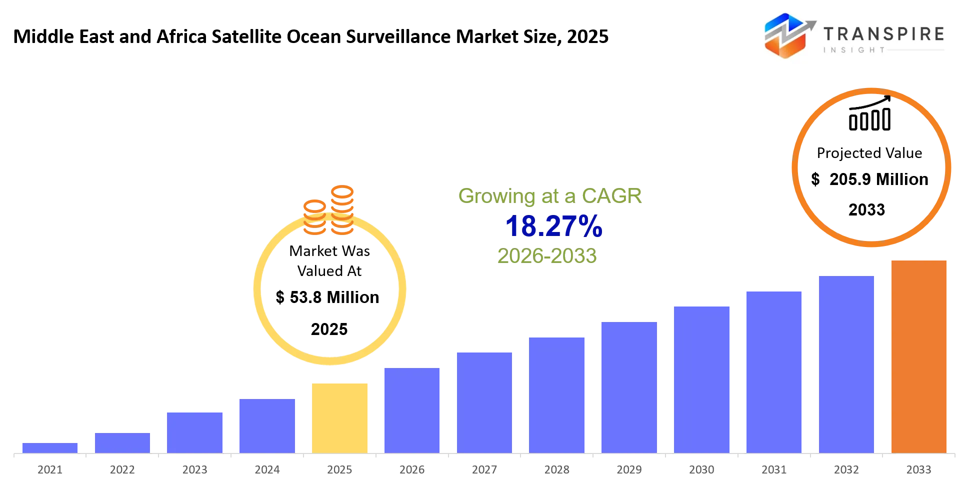
- Middle East and Africa Satellite Ocean Surveillance Market Size 2025: USD 53.8 Million
- Middle East and Africa Satellite Ocean Surveillance Market Size 2033: USD 205.9 Million
- Middle East and Africa Satellite Ocean Surveillance Market CAGR: 18.27%
- Middle East and Africa Satellite Ocean Surveillance Market Segments: By Satellite Type (Radar Satellites, Optical Satellites, AIS Satellites, Hybrid Satellites, Others); By Application (Maritime Security, Fisheries Monitoring, Environmental Monitoring, Search & Rescue, Others); By End User (Defense, Government, Commercial, Others); By Orbit (LEO, MEO, GEO, Others)
To learn more about this report,  Download Free Sample Report
Middle East and Africa Satellite Ocean Surveillance Market Summary
The Middle East and Africa Satellite Ocean Surveillance Market was valued at USD 53.8 Million in 2025. It is forecast to reach USD 205.9 Million by 2033. That is a CAGR of 18.27%over the period.
In the Middle East and Africa Satellite Ocean Surveillance Market, satellites get used to track vessel motion , spot illegal fishing, watch for oil spills, and help keep an eye on maritime border security across very wide ocean corridors. This kind of capability has gotten kind of critical now for both governments and commercial operators trying to manage crowded shipping lanes and also protect high value offshore assets. Over the past five years, the market sorta shifted , not just from separate satellite imaging efforts, but toward joined up multi-sensor intelligence setups that blend radar with AIS records and optical feeds. One of the big sparks behind adoption has been higher maritime security tensions in the Red Sea , and in the Gulf of Aden especially, where defense agencies pushed harder for real time vessel monitoring. At the same time, the commercial offshore energy push brought in more need for continuous ocean visibility, so the demand sort of stacked up. Together these pressures moved procurement away from occasional or periodic surveillance, and more into always-on monitoring platforms, which in turn changed how companies make money , away from one off contracts and toward subscription based satellite intelligence services.
Key Market Insights
- In 2025 the Middle East kind of dominates ~52% share in the Middle East and Africa Satellite Ocean Surveillance Market, mainly because of strategic maritime chokepoints and those naval surveillance investments it keeps pushing.
- Then Africa shows up as the fastest-growing region, especially 2026 to 2033, pulled by illegal fishing control programs and coastal monitoring modernization initiatives.
- When you look at the technology side, radar satellite solutions sit at about ~48% share, which makes sense since there’s that all-weather ocean tracking capability, and it really pulls demand across the region.
- Hybrid satellite systems are the ones that grow fastest from 2024 to 2033, mixing radar, AIS, and optical data, to build integrated maritime intelligence, basically a more coherent picture over time.
- On the applications front, maritime security applications make up ~41% share, and they end up dominating demand in the Middle East and Africa Satellite Ocean Surveillance Market because of geopolitical tensions, sometimes very obvious, sometimes not.
- Fisheries monitoring keeps expanding quickly across West Africa, and as enforcement zones keep increasing, satellite surveillance contracts rise by about ~20% since 2023.
- Defense end-users hold roughly ~46% share too, reflecting strong naval modernization programs across Gulf countries, plus those strategic coastal defense priorities.
- Commercial offshore energy users, on the other hand, expand adoption fast, and that increases satellite surveillance integration by ~25% between 2023 and 2025.
- Key companies named around here include Airbus, Maxar Technologies, ICEYE, Planet Labs, Spire Global, and Thales Group.
- Finally, the strategic expansion angle leans heavily toward AI-enabled maritime analytics, real-time satellite fusion systems, and defense partnerships, to strengthen competitive positioning in practice, not just in slides.
What are the Key Drivers, Restraints, and Opportunities in the Middle East and Africa Satellite Ocean Surveillance Market?
The biggest push behind the Middle East and Africa Satellite Ocean Surveillance Market feels like it’s mostly about maritime security operations getting more intense in key corridors, like the Red Sea, and also the Strait of Hormuz. Over time, naval organizations are leaning harder on satellite tracking, not just in general but to react to vessel dangers, oil smuggling, and those territorial incursions that show up near real time. And this is being made stronger by better blending of radar inputs with AIS satellite data, which in turn cuts down the waiting time for responses. So the accuracy gets better too , and that basically nudges buyers toward subscription oriented surveillance services.
But there is a notable drag. There’s still a heavy dependency on intricate ground infrastructure, plus secure data integration setups. A lot of coastal countries don’t yet have mature analytics hubs, so even when satellite coverage is there , the full operational kickoff can take longer than expected. The consequence is uneven adoption. You see it especially in some lower-income coastal areas in Africa, where funding limits and technical gaps can slow down longer term agreements, and in the end it also reduces how much scalable revenue the providers can actually lock in.
At the same time, there is an emerging opening tied to private offshore energy surveillance and carbon monitoring efforts, mainly across Gulf regions and the West African offshore basins. Oil companies are spending more on continuous satellite observation, partly to meet environmental obligations and partly to guard offshore assets against disruptions. That change is carving out additional commercial revenue, outside the classic defense budgets. It’s also helped by hybrid satellite constellations, because they allow lower latency, higher frequency ocean intelligence delivery, and that seems to be the angle buyers are responding to.
What Has the Impact of Artificial Intelligence Been on the Middle East and Africa Satellite Ocean Surveillance Market?
Artificial intelligence has, in a rather direct way, reshaped satellite driven ocean monitoring by automating things like vessel detection, route grouping and the whole anomaly spotting, across massive maritime zones. In the Middle East and Africa Satellite Ocean Surveillance Market, these AI routines take radar and optical satellite feeds, then they separate commercial shipping , fishing fleets, and also unauthorized vessels with a kind of steady speed and consistency that manual review usually struggles to match. As a result, the monitoring cadence has been shortened a bit and naval command centers get a clearer picture of what’s happening, basically situational awareness, in near real time.
More and more predictive models are getting adopted to guess vessel movement tendencies and flag possible maritime security threats before anything bad really occurs. At the same time, machine learning systems refine satellite tasking timing, so revisit intervals get better over higher risk ocean corridors, and this also helps bring down costs for satellite operators. In offshore energy use cases, AI based analytics back predictive maintenance for maritime assets, by linking ocean condition measurements with equipment stress signals, kind of a correlation based approach.
Overall, these upgrades have led to real improvements in surveillance throughput and compliance checking quality, especially where shipping traffic is dense. Still, there’s a key sticking point that keeps showing up: training data quality stays inconsistent across many African coastal waters, and when historical labeling is limited, model precision drops. Also there can be intermittent connectivity between offshore assets and ground stations, which slows how fast AI inference reaches decision makers, so full scale automation doesn’t quite reach its maximum potential.
Key Market Trends
- After 2022, radar based satellite surveillance… sort of, really kicked up. The Red Sea security disruptions kept getting worse, and that pushed real-time monitoring demand up, like a lot.
- Around 2023 to 2025, AIS data fusion systems became more common, and this improved vessel identity tracking precision across major shipping corridors, even when things were chaotic.
- In 2024, hybrid satellite analytics seems to have grown fastest. Operators were mixing optical, radar and RF detection tools, so they could catch what others might miss in plain sight or in bad weather.
- Also, defense procurement bumped surveillance budgets by something like 30% in Gulf states between 2022 and 2025, specifically for maritime security programs. That part looks pretty clear.
- Meanwhile, illegal fishing enforcement programs rolled out more widely across West Africa after 2023, when policies tightened about exclusive economic zones.
- Commercial offshore energy operators increased satellite monitoring contracts by roughly 25% between 2023 and 2025, mostly for asset protection and not just general awareness.
- AI enabled maritime analytics platforms reduced vessel detection time from hours down to minutes in newer, advanced deployments. It’s a noticeable shift, honestly.
- Private satellite constellations, like ICEYE, expanded and that improved revisit rates over high-risk maritime zones, especially during short windows.
- And post 2023, regional partnerships between European space agencies and Gulf defense bodies strengthened the whole data-sharing infrastructure… you know, the backbone that makes it work.
Middle East and Africa Satellite Ocean Surveillance Market Segmentation
By Satellite Type
Radar satellites pretty much dominate since their all-weather detection can handle tricky maritime scenes, even when the visibility is not great. There is strong adoption in defense surveillance and offshore security monitoring, where sight lines stay problematic, rain or haze still. Optical satellites do their part too, giving high-resolution imagery when conditions are clear enough, and they are commonly used for coastal mapping and for following port activity. AIS satellites, meanwhile, capture vessel identity transmissions so operators can keep tabs on fleets in near real time along shipping lanes.
Hybrid satellites blend radar, optical, and RF sensing, so the output feels more integrated, kind of like one bigger picture. Together these setups back advanced surveillance needs for naval defense and for offshore energy operations. And as more teams integrate multi-sensor satellite systems, the way things run gets more efficient, while data accuracy keeps improving across maritime surveillance uses.
By Application
Maritime Security still seems like the top application, mostly because the geopolitical risks don’t really calm down in those key waterways. Also there is a lot of naval enforcement going on, like constantly, so it stays relevant. Fisheries Monitoring is also growing, mainly from tougher enforcement of territorial waters, plus anti-illegal fishing operations along the African coastlines. Environmental Monitoring is more about oil spill detection and marine ecosystem tracking, especially around offshore drilling areas.
Then the Search & Rescue side is leaning on satellite tracking to find vessels in distress faster and support emergency response coordination, not just locating them but improving the whole flow. Other areas include port logistics optimization and maritime traffic analytics, where the patterns matter.Overall each of these applications depends on real-time satellite intelligence, to help with decisions, and to keep operations safer across maritime industries.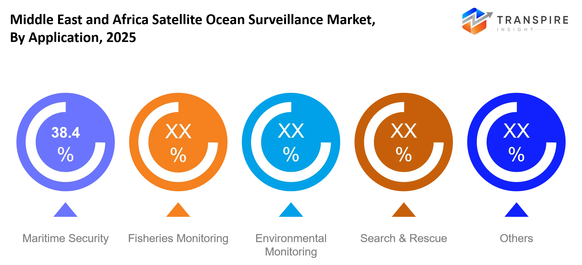
To learn more about this report, Download Free Sample Report
By End User
Defense agencies seem to be the leading end user group, mostly because of national security needs along the major sea lanes. For the government side, maritime authorities often rely on satellite surveillance, not just for border control, but also for customs enforcement and for keeping an eye on illegal activity. On the commercial side, offshore oil operators and shipping firms are increasingly bringing in satellite intelligence to protect valuable assets and to improve route planning.
There are also other users such as research institutions, plus environmental monitoring organizations, who are tracking ocean conditions. Overall, the need across all these end users keeps growing, since satellite data is getting more reachable and cost efficient, which means adoption is spreading well beyond the old defense only use
By Orbit
LEO satellites kind of dominate mainly because they usually have lower latency, more frequent revisit moments, and stronger real time monitoring ability, so it feels more responsive overall. MEO satellites on the other hand give a kind of even or balanced coverage for regional maritime tracking but they are deployed less often, or at least not as much. GEO satellites help with continuous regional watching, however they run into spatial resolution limits for the kind of detailed vessel tracing people want.
There are also other orbit types, like specialized experimental setups, used for niche surveillance missions where the requirements are weirdly specific. Overall LEO constellations are getting serious traction thanks to cost effectiveness, plus they scale easier, and so they tend to become the preferred option for modern maritime surveillance systems across both defense and commercial use.
What are the Key Use Cases Driving the Middle East and Africa Satellite Ocean Surveillance Market?
Maritime security is still basically the main use thing , mostly because naval forces need real time vessel tracking, especially through high-risk corridors like the Red Sea and the Gulf shipping lanes. It’s where the demand is the strongest, since they keep needing constant threat monitoring , plus border enforcement tasks that do n’t really stop.
Then there are fisheries monitoring and offshore energy surveillance, which are getting more attention each year. Government agencies and private operators depend on satellite intelligence to police fishing zones and also to safeguard offshore oil assets from any unauthorized activity. In practice these scenarios feel very tied to defense ministries and to energy companies working along coastal waters.
On top of that , some emerging scenarios are starting to show up, like carbon emissions tracking from vessels and automated insurance risk scoring for maritime claims. These are still sort of in the making but they’re picking up, because regulators and insurers are slowly folding satellite insights into their compliance rules .
|
Report Metrics |
Details |
|
Market size value in 2025 |
USD 53.8 Million |
|
Market size value in 2026 |
USD 63.6 Million |
|
Revenue forecast in 2033 |
USD 205.9 Million |
|
Growth rate |
CAGR of18.27% from 2026 to 2033 |
|
Base year |
2025 |
|
Historical data |
2021 - 2024 |
|
Forecast period |
2026 - 2033 |
|
Report coverage |
Revenue forecast, competitive landscape, growth factors, and trends |
|
Regional scope |
Middle East and Africa (Saudi Arabia, United Arab Emirates, South Africa, Rest of Middle East and Africa) |
|
Key company profiled |
Airbus, Maxar, Planet Labs, ICEYE, Capella Space, Spire Global, HawkEye 360, L3Harris, Thales, Lockheed Martin, Boeing, OHB SE, Satellogic, BlackSky, ESA |
|
Customization scope |
Free report customization (country, regional & segment scope). Avail customized purchase options to meet your exact research needs. |
|
Report Segmentation |
By Satellite Type (Radar Satellites, Optical Satellites, AIS Satellites, Hybrid Satellites, Others); By Application (Maritime Security, Fisheries Monitoring, Environmental Monitoring, Search & Rescue, Others); By End User (Defense, Government, Commercial, Others); By Orbit (LEO, MEO, GEO, Others) |
Which Regions are Driving the Middle East and Africa Satellite Ocean Surveillance Market Growth?
The Middle East leads the Middle East and Africa Satellite Ocean Surveillance Market yeah , mainly because of strong naval infrastructure and that strategic maritime geography. In practice, countries like Saudi Arabia and the UAE keep up fairly advanced satellite-linked monitoring systems, so they can secure key waterways. Also , the big spending on defense modernization plus tighter port security keeps the surveillance need kind of continuous . And there’s an established aerospace and defense ecosystem too, which helps satellite intelligence slot into naval operations without too much friction.
Africa, meanwhile , shows up as a stable contributor, mostly tied to coastal resource protection and fisheries enforcement programs. But unlike the Middle East, the pace there is more shaped by economic development programs and international maritime assistance partnerships , not just heavy defense intensity. Along West and East Africa, governments are gradually adopting satellite monitoring to limit illegal fishing and to support better port governance. So adoption stays consistent , but the cycles usually move slower than what you see across the Gulf region.
North- East Africa is the fastest-growing region, pushed by newer security investments and infrastructure expansion along key shipping lanes. More port development, plus international maritime cooperation programs, has sped up satellite surveillance adoption. This kind of movement also hints at solid long-term opportunities for technology providers , since regional governments are modernizing maritime governance systems sometime between 2026 and 2033.
Who are the Key Players in the Middle East and Africa Satellite Ocean Surveillance Market and How Do They Compete?
The competitive landscape in the Middle East and Africa Satellite Ocean Surveillance Market feels only sort of locked in, kind of moderately consolidated, with some well known aerospace companies on one side, and some newer satellite analytics providers on the other side. In practice, rivalry is mostly pushed by tech know-how, sensor resolution, and real time data blending , not just by pricing. The older players tend to chase broader constellation footprint coverage, while the newer crowd is shaking things up using AI centered analytics setups , plus a specialization angle around synthetic aperture radar.
Airbus banks on heavyweight governmental contracts and Earth observation platforms that get pulled into defense surveillance networks. Maxar Technologies leans into high resolution imaging services , geared toward naval intelligence and offshore monitoring use cases. ICEYE comes through all weather radar imaging , which lets them keep maritime tracking going even when it is cloudy or obstructed.
Spire Global zeroes in on vessel tracking using AIS plus radio frequency monitoring, so they can strengthen real time shipping intelligence. Thales Group grows by means of defense tie ups and secure maritime command system integration across Gulf countries. Overall, these companies go head to head by boosting revisit rates, tying together multi sensor inputs, and building longer term government plus offshore energy relationships , just to lock in repeat surveillance contract work.
Company List
- Airbus
- Maxar Technologies
- Planet Labs
- ICEYE
- Capella Space
- Spire Global
- HawkEye 360
- L3Harris Technologies
- Thales Group
- Lockheed Martin
- Boeing
- OHB SE
- Satellogic
- BlackSky
- European Space Agency (ESA)
Recent Development News
In June 2026, ICEYE secured €1 billion funding led by General Atlantic. The investment strengthens ICEYE’s synthetic aperture radar satellite expansion, enhancing all-weather maritime surveillance capabilities widely used for defense monitoring and ocean intelligence applications across Europe, Middle East, and Africa.http://www.ft.com
In April 2026, ICEYE and IHI Corporation advanced their Earth observation satellite constellation deployment agreement. The first satellites under the partnership are scheduled to begin phased commissioning and data delivery from April 2026, improving continuous maritime monitoring and radar-based ocean surveillance coverage.https://www.iceye.com
In October 2025, Space42 (Yahsat and Bayanat) completed integration of ICEYE SAR satellites for UAE operations. The deployment enhances national maritime surveillance capability by enabling high-resolution radar imaging for coastal security, illegal shipping detection, and offshore infrastructure monitoring.https://www.satellitetoday.com
What Strategic Insights Define the Future of the Middle East and Africa Satellite Ocean Surveillance Market?
The Middle East and Africa Satellite Ocean Surveillance Market is kind of moving, structurally, toward nonstop AI enabled maritime insight ecosystems, rather than just doing those periodic satellite imaging services. You can see it coming from continuous maritime security pressure, and also from the steady expansion of offshore energy infrastructure along key coastlines. Over the next 5–7 years the demand is expected to cluster around integrated platforms that merge radar, optical, and RF satellite data into one unified decision system, so not separate reports and dashboards.
There’s also a less obvious risk, like an overdependence on just a small set of satellite operators, and that could lead to pricing concentration, plus data access bottlenecks for regional governments. It might still look great on paper because demand signals stay strong, but it may slow down true scalability.
On the opportunity side, there’s commercial maritime insurance and carbon compliance monitoring that are starting to get real traction. Satellite-derived analytics are slowly shaping underwriting decisions and regulatory reporting too. Market players should aim for partnerships with defense agencies and offshore energy operators, and at the same time put money into low latency analytics platforms, so they can lock in long-term, contract based revenue.
Middle East and Africa Satellite Ocean Surveillance Market Report Segmentation
By Satellite Type
- Radar Satellites
- Optical Satellites
- AIS Satellites
- Hybrid Satellites
- Others
By Application
- Maritime Security
- Fisheries Monitoring
- Environmental Monitoring
- Search & Rescue
- Others
By End User
- Defense
- Government
- Commercial
- Others
By Orbit
- LEO
- MEO
- GEO
- Others
Frequently Asked Questions
Find quick answers to common questions.
The Expected Middle East and Africa Satellite Ocean Surveillance Market size for the Market will be USD 205.9 Million in 2033.
Key segments for the Middle East and Africa Satellite Ocean Surveillance Market are By Satellite Type (Radar Satellites, Optical Satellites, AIS Satellites, Hybrid Satellites, Others); By Application (Maritime Security, Fisheries Monitoring, Environmental Monitoring, Search & Rescue, Others); By End User (Defense, Government, Commercial, Others); By Orbit (LEO, MEO, GEO, Others)
Major Middle East and Africa Satellite Ocean Surveillance Market Players are Airbus, Maxar, Planet Labs, ICEYE, Capella Space, Spire Global, HawkEye 360, L3Harris, Thales, Lockheed Martin, Boeing, OHB SE, Satellogic, BlackSky, ESA.
The Current Middle East and Africa Satellite Ocean Surveillance Market size is USD 53.8 Million in 2025.
The Middle East and Africa Satellite Ocean Surveillance Market CAGR is 18.27% from 2026 to 2033.
- Airbus
- Maxar Technologies
- Planet Labs
- ICEYE
- Capella Space
- Spire Global
- HawkEye 360
- L3Harris Technologies
- Thales Group
- Lockheed Martin
- Boeing
- OHB SE
- Satellogic
- BlackSky
- European Space Agency (ESA)
About the Authors

Tejashri Dhatrak
I am Tejashri Dhatrak, a Senior Research Analyst at Transpire Insight, specializing in the Aerospace and Defence sector. My work focuses on analyzing industry trends, defence technologies, market developments, and emerging innovations that shape the global aerospace and security landscape. At Transpire Insight, I research complex topics, evaluate credible sources, and transform technical insights into accurate, well-structured, and easy-to-understand content for industry professionals and decision-makers. My goal is to provide reliable, research-backed information that helps readers stay informed about defence capabilities, aerospace advancements, strategic developments, and the evolving dynamics of the global defence ecosystem.

Chakradhar Khansole
Chakradhar serves as the Research Director at Transpire Insight, bringing over 8 years of experience in technology, innovation, and strategic market intelligence. He specializes in transforming complex market data into actionable business insights that enable organizations to make informed, growth-oriented decisions. Recognized for his strategic vision and analytical expertise, Chakradhar leads high-impact research initiatives, delivering comprehensive market assessments, competitive intelligence, and forward-looking industry analysis.
Recently Published Reports
-
Apr 2026
Aerospace Fluoropolymers Market
Aerospace Fluoropolymers Market Size, Share & Analysis Report By Type (PTFE, FEP, PFA, ETFE, and Others), By Application (Electrical Insulation, Seals & Gaskets, Coatings, and Others), By End User (Commercial Aviation, Military Aviation, General Aviation, and Others), and Geography (North America, Europe, Asia-Pacific, Middle East and Africa, South and Central America), 2021 - 2031
-
Apr 2026
Airborne SATCOM System Market
Airborne SATCOM System Market Size, Share & Analysis Report By Type (SATCOM Terminals, Transceivers, Airborne Radio, Modems and Routers, SATCOM Radomes, and Other), By Application (Government and Defense and Commercial), and Geography (North America, Europe, Asia-Pacific, Middle East and Africa, South and Central America), 2021 – 2031
-
Apr 2026
Ship Leasing Market
Ship Leasing Market Size, Share & Analysis Report By Vessel Type (Container Ships, Bulk Carriers, Tankers, and Specialized Vessels), By Lease Duration (Short-Term Lease (Less than 1 year), Medium-Term Lease (1-5 years), and Long-Term Lease (More than 5 years)), By Lease Type (Bareboat Charter, Time Charter, Financial Lease, and Others), By End-User Industry (Oil and Gas, Manufacturing and Industrial, Automotive, Agriculture and Food, Retail and Consumer Goods, and Others), and Geography (North America, Europe, Asia-Pacific, Middle East and Africa, South and Central America), 2021 – 2031
-
Apr 2026
Thread Rolling Dies Market
Thread Rolling Dies Market Size, Share & Analysis Report By Type (Flat Thread Rolling Dies, Circular (Cylindrical) Dies, Tangential Thread Rolling Dies, Planetary Thread Rolling Dies, and Other Types), By Material Type (High-Speed Steel (HSS), Carbide, Tool Steel, Alloy Steel, and Other Specialized Alloys), By Distribution Channel (Direct Sales, Distributors and Dealers, and Online Platforms), By Application (Automotive Industry, Aerospace and Defense, Construction and Infrastructure, Industrial Machinery, Electronics and Electrical Components, Medical Devices, and Fastener Production), and Geography (North America, Europe, Asia-Pacific, Middle East and Africa, South and Central America), 2021 – 2031
Our Clients