
Global Geospatial Analytics Artificial Intelligence Market Size & Forecast:
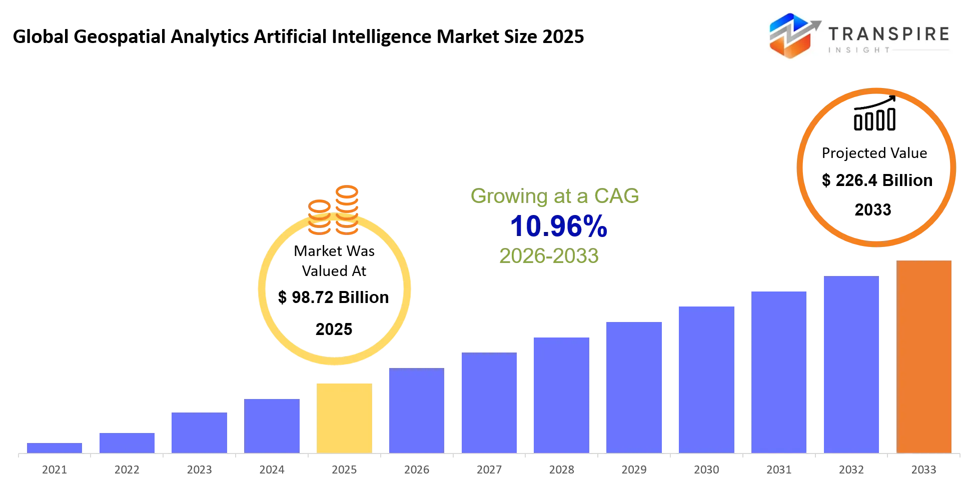
- Global Geospatial Analytics Artificial Intelligence Market Size 2025: USD 98.72 Billion
- Global Geospatial Analytics Artificial Intelligence Market Size 2033: USD 226.4 Billion
- Global Geospatial Analytics Artificial Intelligence Market CAGR: 10.96%
- Global Geospatial Analytics Artificial Intelligence Market Segments: By Component (Software, Services, AI Platforms, Data Analytics, Visualization Tools, Cloud Solutions, Others); By Technology (Machine Learning, Deep Learning, Computer Vision, Natural Language Processing, Predictive Analytics, Others); By Deployment (Cloud, On-premise, Hybrid, Multi-cloud, Others); By End User (Government, Defense, Agriculture, Transportation & Logistics, Utilities, Construction, Others); By Application (Urban Planning, Disaster Management, Precision Agriculture, Infrastructure Monitoring, Environmental Monitoring, Smart Cities, Others)
Global Geospatial Analytics Artificial Intelligence Market Summary:
As per Transpire Insight Analysis, the Global Geospatial Analytics Artificial Intelligence Market size is estimated at USD 98.72 Billion in 2025 and is anticipated to reach USD 226.4 Billion by 2033, growing at a CAGR of 10.96% from 2026 to 2033.
The Global Geospatial Analytics Artificial Intelligence Market is changing the way companies gather and understand information that is related to locations. Companies and government agencies are using satellite pictures, aerial surveys and special sensors with Global Geospatial Analytics Artificial Intelligence to get information. This helps them plan, watch and make decisions. Over the past few years, the Global Geospatial Analytics Artificial Intelligence Market has moved away from old mapping systems. Now it uses Global Geospatial Analytics Artificial Intelligence systems that can understand pictures, find patterns and predict what will happen next. This change happened because more companies are using cloud computing and there is high-quality Earth observation data available. Also, more money is being invested in infrastructure.
One big reason for this change is that people need real-time information about locations in emergency situations when managing infrastructure, in farming and when building cities. Companies want to work faster, so they are using Global Geospatial Analytics Artificial Intelligence solutions that are powered by Global Geospatial Analytics Artificial Intelligence. This helps them get reliable results in many industries.
Key Market Insights:
The Market is shifting towards AI-driven analytic solutions, which allow for quicker, more accurate, and predictive location intelligence. These kinds of technologies are used by businesses and governments to better plan, monitor, and make decisions.
- Software comprises 38% of the Market and involves improvements made by vendors to AI-enabled GIS software through automation, cloud capabilities, and real-time spatial analytics.
- Services constitute 22% of the Market, as businesses become more dependent on consulting, implementation, and managed services to efficiently introduce AI-based geospatial solutions.
- AI Platforms account for 15% of the Market and owe their growth to developments in machine learning models, which help in easier processing of geospatial data.
- Data Analytics makes up 11% of the Market because of the rising need for predictive analytics solutions that will help with infrastructure planning, environment monitoring, and asset management.
- Visualisation Tools comprise 8% of the Market because of improved decision-making processes thanks to dashboards and 3D mapping capabilities.
- Computer Vision Analytics is the fastest-growing segment because of increased use of automatic image interpretation from satellites and drones for real-time monitoring.
- Governmental organisations increase their investments in AI-driven geospatial solutions to enhance their disaster response capability, land management, and infrastructure planning.
What are the Key Drivers, Restraints, and Opportunities in the Global Geospatial Analytics Artificial Intelligence Market?
Drivers
Growth is being driven in the Market by the increased dependence of organisations on geospatial intelligence that uses artificial intelligence. Among the major ones are the use of satellite imagery, drone mapping, and remote sensing technology by sectors such as agriculture, construction, defence, utilities, and transportation. Cloud-based GIS services along with the advancements in machine learning algorithms, have helped organisations to process huge amounts of spatial data much faster. Moreover, initiatives undertaken by governments aimed at the development of smart cities, environment monitoring, and digital infrastructure development have contributed significantly to Market adoption.
Restraints
At the same time, there are still several problems that affect Market expansion negatively. Integration of AI into the geospatial system might cost a lot of money, while there are also some difficulties associated with poor data quality and compatibility. Finally, the lack of specialists able to work with both AI and geospatial analytics has become a problem for organisations.
Opportunities
An important opportunity that could be taken up is the increasing use of computer vision and predictive geospatial analytics. With increasing dependence of industries on real-time location intelligence, AI-based systems could be employed for applications like inspection of infrastructure, disaster management, climate tracking, and precision agriculture. Further investments in cloud computing, earth observation technology, and autonomous vehicles could open up new revenue streams for software companies, analytics firms, and geospatial services firms in the future.
What Has the Impact of Artificial Intelligence Been on the Global Geospatial Analytics Artificial Intelligence Market?
Global Geospatial analytics have gained from AI because it has been made easier and faster through automation of the spatial data interpretation process, which saves time that would have been spent using traditional methods of analysing such data. Artificial Intelligence algorithms are able to process satellite imaging data, aerial images captured by drones, lidar data, and geospatial data in order to be able to understand what is happening on the ground. The benefits of being able to analyse such a massive amount of location data in real time are numerous.
Another big benefit that AI provides in geospatial analytics is in its predictive capacity. Through predictive analysis of historical and real-time geospatial data, one can predict things such as natural disasters, the health of crops, traffic patterns, potential utility network problems, and even possible infrastructure failure.AI has also increased the ability to use computer vision for automated image recognition, making it possible to analyse satellite and aerial images quickly without much human involvement. But the industry is still challenged with issues such as high implementation cost, integration with existing GIS technology, and access to good geospatial data. By solving these constraints through better data management practices and cloud technology, AI will be leveraged even more in the geospatial space. In June 2025, Esri upgraded its GeoAI capability within the ArcGIS system and now allows users to apply AI in their geospatial activities, including satellite image interpretation and processing, feature extraction, predictive spatial analysis, and decision-making processes in geospatial applications. This example shows how AI is being used in geospatial analysis and decision-making processes.
Key Market Trends:
The Market is moving away from traditional map-making through the combination of artificial intelligence and geospatial intelligence that enables quick and predictive analysis. Many firms are spending money on intelligent spatial analytics to improve performance and make real-time decisions.
- Manual image analysis is becoming history since new technologies are being developed that can enable automatic analysis of satellite and drone images.
- Most organisations prefer cloud-based geospatial solutions since they offer flexibility when managing large-scale location datasets.
- Businesses have been automating operations through computer vision technologies, which include object detection, land classification, infrastructure inspection, and environmental monitoring.
- There has been a growth in digital twin technology by integrating AI and geospatial data to create dynamic models for various cities, assets, and transportation networks.
- IoT sensors are now being used with geospatial data to continuously monitor utilities, agriculture, logistics, and infrastructure.
- Organizations are using predictive geospatial analytics to anticipate future events such as natural disasters and improve disaster preparedness efforts.
- There has been an increase in government investment in geospatial intelligence solutions to implement smart cities, national security and climate resilience programs.
Global Geospatial Analytics Artificial Intelligence Market Segmentation
By Component
Software is the most significant Market segment, accounting for 38% and acting as the basis of AI geospatial analytics solutions. More and more businesses today utilise software solutions for analysing satellite images, automating spatial analysis and creating real-time location intelligence. Constant advancements in cloud GIS software, AI algorithms and data visualisation techniques are contributing to higher adoption rates within various industries. Services account for 22% of the Market because of the increased demand for consultancy, systems integration and maintenance. AI Platforms take 15%, Data Analytics takes 11%, Visualisation Tools take 8%, while Others make up 6% of the Market.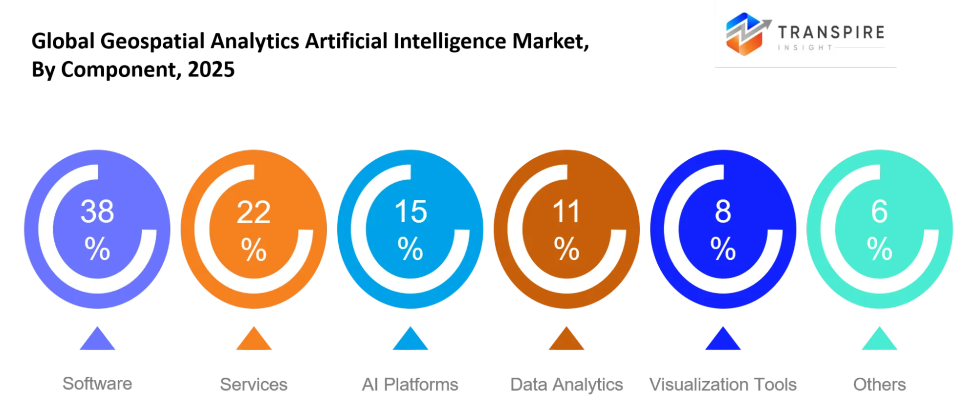
By Technology
Of all technologies, Computer Vision Analytics is the fastest-growing one. This is because computer vision analytics automatically recognises objects and uses classification of land use and infrastructure inspection using satellite and drone images. The accuracy of predictive geospatial models is continually improving due to machine learning and deep learning, and spatial information can be accessed more easily thanks to natural language processing. All of these innovations are allowing businesses to convert vast amounts of geospatial data into actionable business intelligence.
By Deployment
Cloud deployment is becoming more preferred since it offers scalable computing capacity, fast data processing, and easier integration with the use of AI-driven analytics platforms. The deployment of hybrid models has also been increasing among enterprises that need to have a balance between data security and flexibility. The on-premises deployment has continued to be significant within industries dealing with geospatial data, which are highly sensitive, especially by government and defence agencies, but cloud deployment has continued to increase significantly.
By End User
Government agencies have remained some of the biggest users of AI-driven geospatial analytics, using these tools for purposes of land management, urban planning, disaster recovery, and environment monitoring. Advanced spatial intelligence is used by defence agencies in enhancing their surveillance activities and strategic planning. Agricultural, utility, construction, and transportation industries have continued to adopt geospatial analytics in improving asset management.
By Application
Urban planning is yet another application domain that still remains one of the most important because cities need AI-enabled geospatial intelligence to create smart cities and develop their infrastructure. Disaster management solutions are becoming increasingly popular owing to their ability to speed up the process of risk assessment and emergency management. Precision agriculture, infrastructure management, environment management, and smart city initiatives provide additional domains where organisations can apply geospatial intelligence.
What are the Key Use Cases Driving the Global Geospatial Analytics Artificial Intelligence Market?
Artificial intelligence-based geospatial analytics is extensively used for urban planning and infrastructure management, which constitute key applications of the Market. Organisations use software-based platforms, being the biggest segment of the Market, to analyse satellite imagery, monitor land usage, manage transportation, and develop smart cities with precise location-based information.
In addition to that, the technology is also penetrating the areas of precision agriculture, disaster management, environment monitoring, and utilities. With the help of artificial intelligence-based geospatial analytics, organisations can monitor crop health, monitor changes in the environment, assess the impact of natural disasters, and even inspect infrastructure thanks to automated image processing.
Potential applications include autonomous transportation, climate risk assessment, renewables planning, and development of digital twins. With computer vision analytics being the fastest-growing technology segment, further development means more organisations are using AI-powered geospatial intelligence to automate spatial analysis and increase forecast accuracy.
|
Report Metrics |
Details |
|
Market size value in 2025 |
USD 98.72 Billion |
|
Market size value in 2026 |
USD 109.3 Billion |
|
Revenue forecast in 2033 |
USD 226.4 Billion |
|
Growth rate |
CAGR of 10.96% from 2026 to 2033 |
|
Base year |
2025 |
|
Historical data |
2021 - 2024 |
|
Forecast period |
2026 - 2033 |
|
Report coverage |
Revenue forecast, competitive landscape, growth factors, and trends |
|
Regional scope |
United States; Canada; Mexico; United Kingdom; Germany; France; Italy; Spain; Denmark; Sweden; Norway; China; Japan; India; Australia; South Korea; Thailand; Brazil; Argentina; South Africa; Saudi Arabia; United Arab Emirates |
|
Key company profiled |
Esri, Hexagon AB, Google, Microsoft, IBM, Oracle, Maxar Technologies, Planet Labs, Autodesk, Bentley Systems, NVIDIA, Amazon Web Services, Trimble, HERE Technologies, SAP |
|
Customization scope |
Free report customization (country, regional & segment scope). Avail customized purchase options to meet your exact research needs. |
|
Report Segmentation |
By Component (Software, Services, AI Platforms, Data Analytics, Visualization Tools, Cloud Solutions, Others); By Technology (Machine Learning, Deep Learning, Computer Vision, Natural Language Processing, Predictive Analytics, Others); By Deployment (Cloud, On-premise, Hybrid, Multi-cloud, Others); By End User (Government, Defense, Agriculture, Transportation & Logistics, Utilities, Construction, Others); By Application (Urban Planning, Disaster Management, Precision Agriculture, Infrastructure Monitoring, Environmental Monitoring, Smart Cities, Others) |
Which Regions are Driving the Global Geospatial Analytics Artificial Intelligence Market Growth?
North America
North America occupies 44% of the global Market share and is the leading contributor to the Market. This region enjoys a well-established digital infrastructure, a high-level use of AI-based geospatial technologies and heavy investment in satellite imaging and cloud-based geographic information systems. The government bodies, military forces, and commercial firms keep increasing the applications of geospatial intelligence in infrastructure, environment, and security. The presence of major tech companies and technological developments in the region helps North America maintain its leading position in the Market.In June 2025, Esri announced new developments in GeoAI at its developer conferences, showing how artificial intelligence was becoming more deeply integrated into the ArcGIS platform for automated geospatial analysis, satellite imagery processing, and spatial decision-making by government and business entities in North America.
Europe
Europe occupies 25% of the global Market and keeps growing steadily due to the focus on sustainable practices, environmental management, and digital transformation. Across the region, there is an increasing use of AI-based geospatial solutions to monitor the climate, enable smart mobility and develop cities. There are well-developed regulations for spatial data sharing and continued investment in Earth observation programs, which contribute to adoption within both public and private sectors.In May 2025, the Copernicus program supported the use of AI-powered Earth observation services at the GEO Global Forum, showing how artificial intelligence and geospatial analytics were being used to enhance environmental monitoring, climate intelligence, and decision-making by governments in Europe.
Asia Pacific
Asia Pacific constitutes 22% of the total global Market and is expected to have the fastest growth rate of 23.4% CAGR. Increased urbanisation and investments in digital infrastructure, along with increased demand for intelligent cities, have accelerated the need for AI-powered geospatial technology solutions. The adoption of satellite imagery and drone imaging, along with predictive geospatial technologies, is increasing in Asia Pacific for various applications like agriculture, disaster management, and infrastructure development. Government support and private sector investments are expected to continue fueling the momentum of growth in the region. In January 2025, Planet Labs reached a record agreement with a commercial entity in the Asia-Pacific region for developing dedicated Earth observation satellites.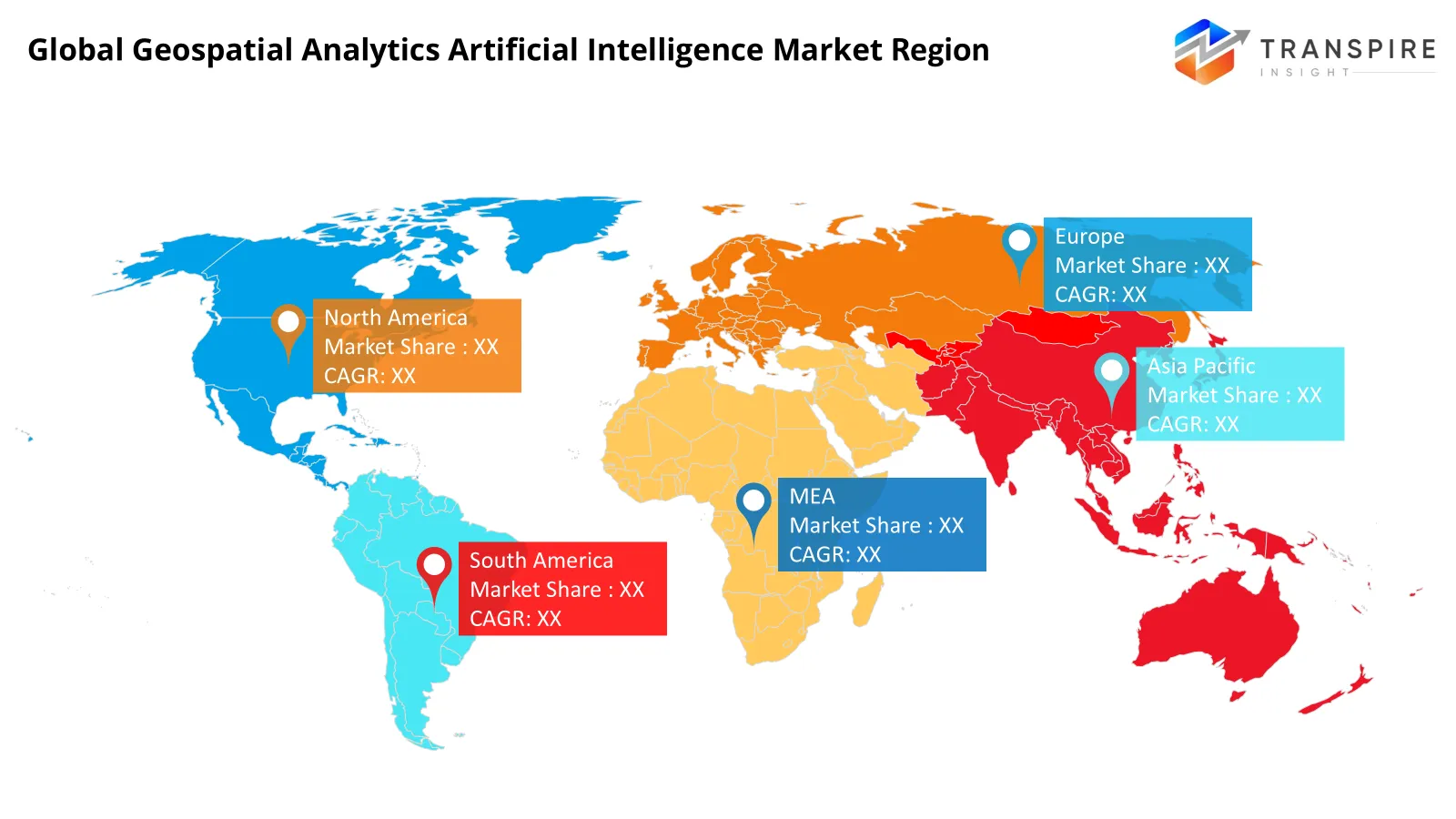
Who are the Key Players in the Global Geospatial Analytics Artificial Intelligence Market and how do they Compete?
The Global Geospatial Analytics Artificial Intelligence Market is highly competitive, where technology firms, GIS software providers, and cloud platform suppliers compete on the basis of innovation, integration of AI, and industry-specific solutions. The competition in the Market is based on the capability to provide accurate spatial intelligence, cloud scalability, automatic image analysis, and predictive analytics. Further, companies are increasing their Market penetration by forming partnerships and acquiring firms along with investing heavily in R&D.
Top providers are developing unique value propositions through the extension of their AI-powered geospatial solutions into various industries including government, defence, agriculture, construction, transportation, and utilities. Esri continues to add more AI and machine learning features along with cloud analytics to its ArcGIS suite of products. On the other hand, Hexagon AB concentrates on combining AI with geospatial intelligence, digital reality solutions, and autonomous technologies. Finally, Maxar Technologies utilises high-resolution imagery along with artificial intelligence analytics for defence, environmental monitoring, and emergency services.
Global Geospatial Analytics Artificial Intelligence Market companies
- Esri
- Hexagon AB
- Microsoft
- IBM
- Oracle
- Maxar Technologies
- Planet Labs
- Autodesk
- Bentley Systems
- NVIDIA
- Amazon Web Services
- Trimble
- HERE Technologies
- SAP
Recent Development News
In February 2025, in association with Maxar Technologies and SkyWatch, Esri developed the Content Store for ArcGIS, providing high-resolution satellite imagery from the commercial sector in the ArcGIS software itself. This has made image acquisition easier and improved the workflow for geospatial analysis using AI technology.
https://www.businesswireindia.com
In March 2026, Successive Digital formed a strategic alliance with Esri India to enhance geospatial solutions for the enterprise. This alliance seeks to fast-track the implementation of GIS enabled by AI, location intelligence, and digital transformation technologies.
What Strategic Insights Define the Future of the Global Geospatial Analytics Artificial Intelligence Market?
Future developments in the Market for Global Geospatial Analytics Artificial Intelligence will involve the development of intelligent cloud-based platforms capable of delivering real-time location intelligence and decision support solutions. The future development of the Market will depend on further integration of AI with satellite imaging, drones, IoT sensors, and digital twin technology to enable automated spatial analysis and increased efficiency in operations.
One of the main opportunities that will be available in the Market in the near future is related to the expansion of smart cities, precision agriculture, infrastructure management, and climate resilience solutions, where geospatial intelligence is an important element of operations. At the same time, the challenge of acquiring standardised and high-quality geospatial data and difficulties with the integration of AI into existing GIS solutions will remain hidden. Companies that invest in scalable cloud-based platforms, computer vision capabilities, and AI solutions in specific industries will be able to gain an advantage over the next few years.
By Component
- Software
- Services
- AI Platforms
- Data Analytics
- Visualization Tools
- Cloud Solutions
By Technology
- Machine Learning
- Deep Learning
- Computer Vision
- Natural Language Processing
- Predictive Analytics
By Deployment
- Cloud
- On-premise
- Hybrid
- Multi-cloud
By End User
- Government
- Defense
- Agriculture
- Transportation & Logistics
- Utilities
- Construction
By Application
- Urban Planning
- Disaster Management
- Precision Agriculture
- Infrastructure Monitoring
- Environmental Monitoring
- Smart Cities
Regional Outlook
North America
- United States
- Canada
- Mexico
Europe
- Germany
- United Kingdom
- France
- Spain
- Italy
- Rest of Europe
Asia Pacific
- Japan
- China
- Australia & New Zealand
- South Korea
- India
- Rest of Asia Pacific
South America
- Brazil
- Argentina
- Rest of South America
Middle East & Africa
- Saudi Arabia
- United Arab Emirates
- South Africa
- Rest of the Middle East & Africa
Frequently Asked Questions
Find quick answers to common questions.
The Global Geospatial Analytics Artificial Intelligence Market size was valued at USD 98.72 Billion in 2025 and is poised to reach USD 226.4 Billion by 2033, expanding at a 10.96% CAGR.
Key segments for the Global Geospatial Analytics Artificial Intelligence Market are By Component (Software, Services, AI Platforms, Data Analytics, Visualization Tools, Cloud Solutions, Others); By Technology (Machine Learning, Deep Learning, Computer Vision, Natural Language Processing, Predictive Analytics, Others); By Deployment (Cloud, On-premise, Hybrid, Multi-cloud, Others); By End User (Government, Defense, Agriculture, Transportation & Logistics, Utilities, Construction, Others); By Application (Urban Planning, Disaster Management, Precision Agriculture, Infrastructure Monitoring, Environmental Monitoring, Smart Cities, Others).
The key factors that drive growth include the surge in demand for geospatial intelligence, fast adoption of AI and machine learning, smart city programs, satellite & drones’ data usage, and various applications in defence, agriculture, transport, and urban planning.
The global Market is led by major manufacturers including Esri, Hexagon AB, Google, Microsoft, IBM, Oracle, Maxar Technologies, Planet Labs, Autodesk, Bentley Systems, NVIDIA, Amazon Web Services, Trimble, HERE Technologies, and SAP.
North America dominates the share of the Global Geospatial Analytics Artificial Intelligence Market to the extent of 44%, owing to wide adoption of AI technology, robust geospatial systems, heavy spending on defence as well as smart cities projects, and presence of technology players.
The commercial applications of GIS include more development in location intelligence services based on artificial intelligence, greater use of geospatial analysis in smart cities and infrastructure projects, higher demand for precision agriculture, defence and public safety use cases, and logistics/transportation/environmental monitoring applications.
- Esri
- Hexagon AB
- Microsoft
- IBM
- Oracle
- Maxar Technologies
- Planet Labs
- Autodesk
- Bentley Systems
- NVIDIA
- Amazon Web Services
- Trimble
- HERE Technologies
- SAP
About the Authors

Mayur Shinde
I am Mayur Shinde, a Senior Research Analyst at Transpire Insight, specializing in the Automotive & Transportation and Information & Communication Technology (ICT) Industry. My work focuses on analyzing emerging market trends, technological advancements, competitive landscapes, and industry developments to deliver accurate, data-driven insights. I am passionate about transforming complex market information into clear, actionable content that helps businesses, professionals, and decision-makers stay informed and make confident strategic decisions.

Chakradhar Khansole
Chakradhar serves as the Research Director at Transpire Insight, bringing over 8 years of experience in technology, innovation, and strategic market intelligence. He specializes in transforming complex market data into actionable business insights that enable organizations to make informed, growth-oriented decisions. Recognized for his strategic vision and analytical expertise, Chakradhar leads high-impact research initiatives, delivering comprehensive market assessments, competitive intelligence, and forward-looking industry analysis.
Recently Published Reports
-
Apr 2026
3D Optical Profiler Market
3D Optical Profiler Market Size, Share & Analysis Report By Type (Desktop 3D Optical Profiler, and Portable 3D Optical Profiler), By Technology (Confocal Technology, and White Light Interference), By End-Use Industry (Manufacturing, Research Institutions, Automotive, Aerospace and Defense, Medical Devices, and Other), and Geography (North America, Europe, Asia-Pacific, Middle East and Africa, South and Central America), 2021 - 2031
-
Apr 2026
Depth Sensor Market
Depth Sensor Market Size, Share & Analysis Report By Type (Infrared Depth Sensors, Time-of-Flight (ToF) Sensors, Stereo Vision Sensors, Structured Light Sensors, Ultrasonic Depth Sensors), By Application (Automotive, Robotics, Gaming, Consumer Electronics, Industrial Automation, Healthcare, Security & Surveillance, Others), By End Users (Automotive Manufacturers, Consumer Electronics Companies, Healthcare Providers, Industrial Companies, Security Agencies, Gaming Companies, Robotics Companies, Others), and Geography (North America, Europe, Asia-Pacific, Middle East and Africa, South and Central America), 2021 – 2031
-
Apr 2026
Digital Manufacturing Market
Digital Manufacturing Market Size, Share & Analysis Report By Component (Hardware, Software, and Services), By Technology (Robotics, 3D Printing, Internet of Things (IoT), and Others), By Application (Automotive and Transportation, Aerospace and Defense, Consumer Electronics, Industrial Machinery, and Others), By Process Type (Computer-Based Designing, Computer-Based Simulation, Computer 3D Visualization, Analytics, and Others), and Geography (North America, Europe, Asia-Pacific, Middle East and Africa, South and Central America), 2021 – 2031
-
Apr 2026
Digital Visa Services Market
Digital Visa Services Market Size, Share & Analysis Report By Type (Individual Travelers, Group Travelers), By Application (Tourism, Business Travel, Others), and Geography (North America, Europe, Asia-Pacific, Middle East and Africa, South and Central America), 2021 – 2031