
United States Commercial Drones Market Summary
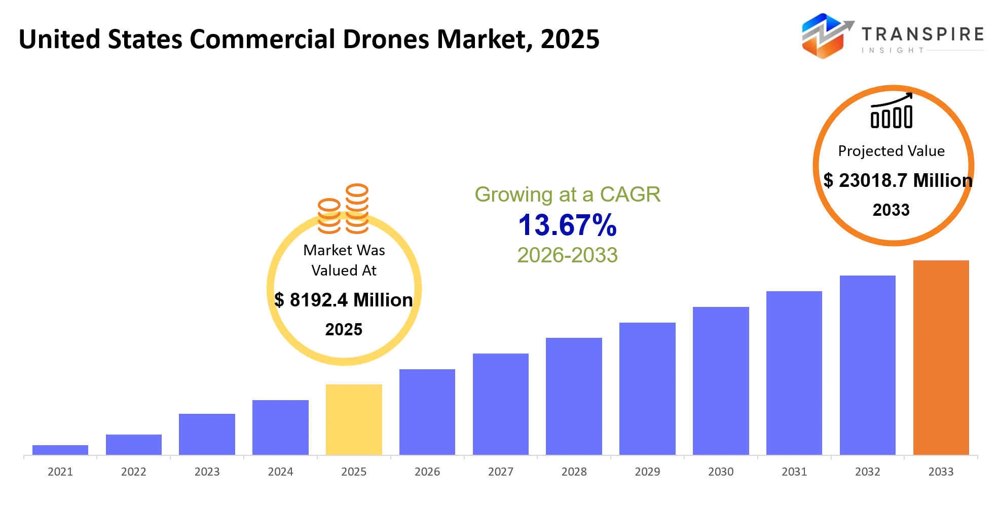
As per Transpire Insight Analysis the United States Commercial Drones Market size is estimated at USD 8192.4 Million in 2025 and is anticipated to reach USD 23018.7 Million by 2033, growing at a CAGR of 13.67% from 2026 to 2033.
The United States commercial drone market sort of lets companies gather aerial data, do checks on places that are hard to reach, measure or map sites, keep an eye on crop health, and transport small payloads without really risking workers or regular aircraft. In the last 3–5 years, day to day use has kind of moved away from manually piloted aircraft, and toward more autonomous platforms that come with AI navigation, upgraded imaging, and automated data handling. At the same time FAA Remote ID rules, plus more general digital airspace management, have nudged operators into using fleets that are more traceable and easier to stay compliant with.
One big trigger lately is rising U.S. concern about how much the country depends on Chinese-made drone tech. That pressure is pushing more domestic procurement, and also investment into firms that promise secure supply chains. Overall market growth is projected to move from USD 8,192.4 million in 2025 to USD 23,018.7 million by 2033 ,mainly because utilities, construction firms, agricultural operators, logistics providers, and public agencies are looking to trade slower manual checks for repeatable aerial workflows. AI-enabled inspection is helping along with autonomous navigation, and the ongoing growth of delivery initiatives is also shifting drone work from one off efforts into more continuous operational offerings, basically a system that can be redeployed and redeployed again, over and over.
United States Commercial Drones Market Size & Forecast:
- United States Commercial Drones Market Size 2025: USD 8192.4 Million
- Expected Market Value 2033: USD 23018.7 Million
- Forecast CAGR:13.67%
- Key Profile: DJI, Skydio, AeroVironment, Parrot Drones, AgEagle Aerial Systems, Teledyne FLIR, Anduril Industries, Red Cat Holdings, Wing (Alphabet), Zipline, Boeing Insitu, Freefly Systems, Draganfly Inc., Autel Robotics, Quantum Systems
Key Market Insights
- Market scale: Industry revenue is forecast to drift up from USD 8,192.4 million in 2025 to USD 23,018.7 million by 2033, roughly speaking.
- Regional leadership: Western states are still holding the lead spot, powered by technology spending, agriculture, utilities, construction and also those already-solid drone-service ecosystems, so it feels like momentum there.
- Fastest regional expansion: Southern states are building speed lately, because infrastructure work keeps expanding, energy projects are ramping up, logistics activity is louder, and public-safety deployments are showing up more often.
- Drone configuration shift: Rotary-wing platforms keep dominating commercial rollouts, but hybrid VTOL setups are getting more attention for extended missions that need vertical takeoff, and landing versatility.
- Autonomy transition: AI navigation has kind of slid from “premium feature” territory into real operational plumbing, with Skydio stating inspections get done up to 3x faster, in practical terms.
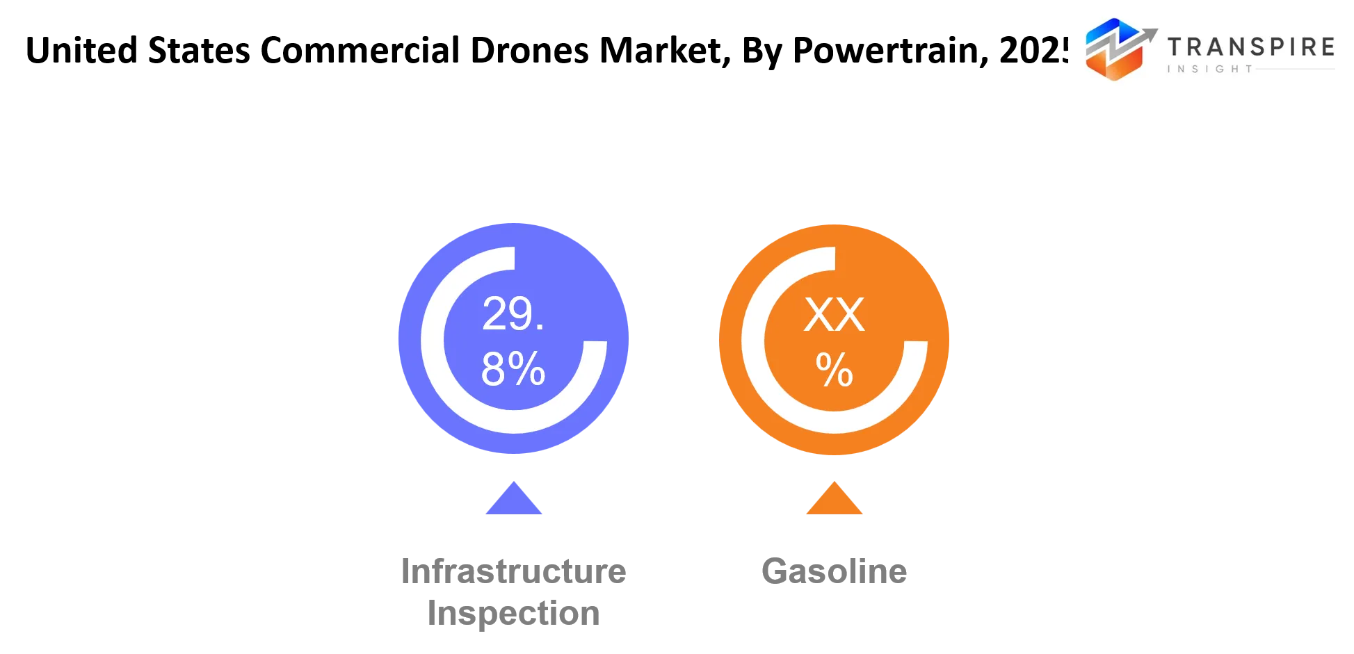
- Inspection leadership: Infrastructure inspection stays a big revenue engine, as utilities rely on thermal and visual imaging to flag equipment faults from a distance, without sending people in immediately.
- Regulatory transition: Since 2021, routine night work has been run under updated Part 107 rules, which trims a prior regulatory constraint, for sure.
- Compliance technology is kinda pushing remote ID rules, so a bunch of commercial operators are shifting toward aircraft that can be identified, with compliant software stacks and also stronger fleet management routines.
- Domestic sourcing. Since 2024, geopolitical pressure has boosted the appetite for U.S. made platforms and for secure component supply chains, which buyers really need across both enterprise and government teams.
- Enterprise adoption, Skydio points out deployment across the top four U.S. utilities and also more than 280 other utilities. That kind of signals the move toward more repeatable industrial drone programs, not just one off trials.
What are the Key Drivers, Restraints, and Opportunities in the United States Commercial Drones Market?
Driver: The strongest growth momentum is kinda the shift from buying drone hardware toward more repeatable industrial workflows. Utilities, construction companies, energy operators, and public agencies can lean on aerial platforms for inspections, mapping, emergency assessment, and ongoing asset monitoring, without having to keep sending out big field crews over and over. AI navigation plus high-resolution thermal or visual sensors really sharpens the economics, because it cuts inspection time and lowers the time staff spend around dangerous places. Skydio says utility inspections can be done up to three times faster, which basically means productivity gains can back wider rollouts.
Restraint: Airspace rules are still a structural limitation, especially when it comes to BVLOS operations. FAA requirements continue to call for waivers for many flights that fall outside standard Part 107 constraints, and for most routine BVLOS activity , you still need the right authorization. All of that regulatory overhead adds approval lag, bumps up operational planning costs, and it ultimately caps how large autonomous inspection and delivery networks can get.
Opportunity: The biggest forward opportunity is autonomous BVLOS deployment that’s supported by dependable navigation, Remote ID, detect and avoid systems, and centralized fleet software. As regulators keep developing clearer pathways, plus the U.S. investment push behind domestic drone manufacturing, operators might be able to manage larger fleets across utilities, logistics, agriculture, and public safety too.
What Has the Impact of Artificial Intelligence Been on the United States Commercial Drones Market?
Artificial intelligence is shifting commercial drone work from, sort of manually piloted flights into data-led inspection and monitoring routines that are more automated. With computer vision, the system can flag damaged infrastructure, vegetation encroachment, construction progress, different objects, and other visual oddities, all by looking at aerial imagery. At the same time AI navigation supports obstacle avoidance and helps keep the aircraft on steadier flight lines. For example Skydio’s autonomous navigation uses AI for inspection tasks in tricky utility settings, and it can function without needing GPS 100% of the time.
Machine learning also helps with image labeling, asset-condition evaluation, route planning, and even automated summaries. In practice, these features cut down the raw aerial footage that would otherwise need a person’s manual review, and they can shrink the gap between collecting the data and making maintenance choices. Skydio states that inspection operations can run up to three times faster for utility networks, which gives a concrete, measurable improvement signal.
Still, adopting AI isn’t effortless , there are integration expenses, not enough high-quality training datasets, connectivity limitations, and accuracy issues when conditions behave unexpectedly. The specific AI-based scrubber monitoring example you mentioned feels more aligned with maritime exhaust-gas systems, rather than the U.S. commercial drone landscape. For drones, the better fit tends to be infrastructure inspections, environmental observation, autonomous navigation, and aerial data analysis.
Key Market Trends
- Since 2021, revised FAA rules have been a bit simpler with routine nighttime ops, so commercial inspection schedules can run longer.
- Since 2024, the geopolitical situation has pushed enterprise interest in U.S.-made drones, and more secure tech supply chains, even more.
- AI navigation has kinda moved along from “nice extra” advanced functionality to real core enterprise capability, especially for complicated infrastructure inspection work.
- Utility operators are also leaning more into drones for repeated inspections, and Skydio says it has deployments spanning over 280 utilities.
- At the same time Remote ID rules are steering procurement toward aircraft, software, and fleet-management systems built around traceability and compliance.
- For construction users it’s changing too, from occasional aerial photography into continuous surveying, progress monitoring, mapping, and on-site documentation.
- Logistics firms are going beyond pilot programs as autonomous delivery networks get better at route planning, payload handling, and that repeatability thing operationally.
- Enterprise buyers are, meanwhile, increasingly choosing a stitched together set up with thermal cameras , AI analytics , navigation systems, and cloud platforms, rather than plain standalone aircraft.
- Government and public safety teams are putting additional weight on more secure domestic platforms after concerns, about being too dependent on foreign drone technology.
- BVLOS capability is still a major industry goal, but waiver requirements still, kind of, restrict large-scale autonomous commercial rollouts.
United States Commercial Drones Market Segmentation
By Drone Type
Fixed-Wing drones can support long distance surveying , mapping, agriculture monitoring, and environmental assessment, because these fixed wings they do efficient forward flight , and the coverage can stretch out much farther. Rotary-Wing drones support inspection work , photography, construction monitoring, and public safety too , due to vertical takeoff and hovering letting them operate in tight or restricted places. Hybrid VTOL drones basically mix vertical takeoff with longer forward flight, so hybrid platforms are often suited for infrastructure surveys and for larger scale mapping. Then you have nano drones , mini drones , and micro drones that cover indoor inspection, security, training, and compact commercial missions, where the whole portability thing is still a big deal.
Tactical drones handle surveillance , emergency response, and more specialized government operations, while heavy-lift drones are built around cargo movement, industrial tasks, and those specialized delivery activities. Delivery drones focus on medical shipments, food delivery, retail logistics, and other time sensitive transportation services. “Others” might include specialized aircraft meant for research, environmental monitoring, security, and customized industrial requirements. Improvements in battery systems, autonomous navigation, payload capacity, and obstacle detection will help enable wider use across everyday commercial operations, honestly more people will get to use them.
By Component
Airframe design in general affects how long it lasts, what weight it can carry, how much endurance you get, and even how efficiently it can operate, while Propulsion Systems more or less determine speed , flight time and the ability to lift. Navigation Systems help with precise location via GPS, inertial systems, visual navigation, and also autonomous controls, kind of, depending on setup. Then Sensors and Cameras deliver the kind of information people actually need , like visual, thermal, multispectral, LiDAR, plus other data, for inspections, agriculture, mapping, and environmental tracking. Payloads, meanwhile, widen the commercial options using cameras, delivery hardware, spraying systems and specialized sensing devices.
Communication Systems usually back command exchange, telemetry, video sending, and coordinating an entire fleet, and Ground Control Stations are what enable mission planning , along with flight monitoring. Software handles route planning, data processing, mapping, analytics, compliance work, and fleet operations. The rest is the practical stuff like batteries, charging systems, storage equipment, launch mechanisms and replacement components. Over time, improvements in software, batteries, sensors ,and comms tech should make aircraft better overall and allow for bigger commercial fleets.
By Application
Agriculture uses drones kind of for crop monitoring field mapping plant-health assessment spraying and also irrigation analysis , while Construction relies on aerial surveys progress tracking measurements and site documentation, sort of. Infrastructure Inspection takes care of bridges, roads , towers, power lines , pipelines and industrial facilities through visual and thermal imaging. Logistics & Delivery covers last-mile transportation medical shipments warehouse operations and urgent deliveries. Energy & Utilities uses drones for transmission lines, substations pipelines, solar facilities wind turbines, and industrial assets as well.
Mining uses aerial platforms for stockpile measurement terrain mapping pit monitoring and site planning. Media & Entertainment uses drones for aerial photography filming advertising sports coverage and live events. Public Safety applications include search and rescue disaster assessment firefighting support and emergency monitoring, while Environmental Monitoring supports habitat assessment vegetation analysis erosion mapping and wildlife observation . Others are real estate, insurance inspection, telecommunications , security , research, and specialized surveying.
By End User
Commercial Enterprises often use drones for inspection, surveying, documentation, security and operational planning, but Government Agencies lean more toward aerial systems for public safety infrastructure assessment , emergency response, plus environmental monitoring. Agriculture Companies typically employ drones for crop scouting, field mapping , spraying, and plant health assessment. Construction Firms apply drone technology to surveying, progress monitoring, measurement , mapping, and assorted safety activities. Energy Companies use aerial platforms for powerline, pipeline, solar, wind and facility inspections.
Logistics Providers use drones for last mile delivery and time sensitive transportation, whereas Media Companies use aerial systems for filming, photography , advertising and event coverage. Research Institutes tend to apply drones to environmental studies, engineering research, mapping, agriculture, and even autonomous system development. Other players include insurance companies, telecommunications providers, mining operators, real estate firms, and specialized service providers. The demand coming from enterprise and government users should help drive faster adoption of integrated aircraft, payload, software, and fleet management systems.
By Range
Short range drones are for close inspection, sort of indoor observation, construction documentation, and local surveying, and Medium range drones are more for agriculture, infrastructure inspection, mapping, and industrial monitoring over wider spaces. Long range drones are used for bigger surveying jobs, environmental monitoring, pipeline inspection, and large area mapping. Beyond Visual Line of Sight , BVLOS, operations allow longer missions without constantly having direct line of sight, and they can stretch inspection monitoring, and even delivery use cases. Visual Line of Sight, VLOS, ops are still super common for construction, agriculture, inspection, and public safety tasks.
Autonomous drones lean on software, sensors, navigation systems, and artificial intelligence so missions run with only limited operator input. Semi autonomous drones mix automated flying bits with human supervision for route following, obstacle avoidance, plus takeoff and landing. There are also other variants, like specialized platforms with tweaked endurance, stronger communications, tethered operation, or mission specific reach. Ongoing upgrades in autonomous navigation, communication networks, battery technology, and regulatory frameworks should help broaden adoption for longer-range and more automated drone operations.
What are the Key Use Cases Driving the United States Commercial Drones Market?
Infrastructure inspection kinda keeps showing up as a top commercial use case, since utilities , construction firms ,and energy providers still need frequent asset assessments without sending people right up near towers power apparatus bridges, and nasty terrain. Drones give visual, thermal and mapping info from more stable operating spots, and they also cut the on site inspection time, even if the crews had been doing fine before.
Agriculture and construction are also getting close to the same ideas . In agriculture, companies lean on aerial imagery for crop observation and more controlled precision field management, while construction teams use drones for surveying, progress tracking, measurements and site documentation all at once. Public safety agencies sometimes push drones too, for emergency evaluation, search activity, and disaster response, depending on what’s happening.
Newer directions are getting louder, like autonomous delivery, continuous remote monitoring for infrastructure, and bigger BVLOS inspection networks. FAA authorization still sits as a major requirement for wider BVLOS rollout, especially for regular commercial operations . As autonomous navigation , secure communications, and fleet software keep improving, these efforts should evolve into larger recurring drone-service programs rather than just one off flights that happen once and then disappear.
|
Report Metrics |
Details |
|
Market size value in 2025 |
USD 8192.4 Million |
|
Market size value in 2026 |
USD 9395.5 Million |
|
Revenue forecast in 2033 |
USD 23018.7 Million |
|
Growth rate |
CAGR of 13.67% from 2026 to 2033 |
|
Base year |
2025 |
|
Historical data |
2021 - 2024 |
|
Forecast period |
2026 - 2033 |
|
Report coverage |
Revenue forecast, competitive landscape, growth factors, and trends |
|
Regional scope |
United States |
|
Key company profiled |
DJI, Skydio, AeroVironment, Parrot Drones, AgEagle Aerial Systems, Teledyne FLIR, Anduril Industries, Red Cat Holdings, Wing (Alphabet), Zipline, Boeing Insitu, Freefly Systems, Draganfly Inc., Autel Robotics, Quantum Systems |
|
Customization scope |
Free report customization (country, regional & segment scope). Avail customized purchase options to meet your exact research needs. |
|
Report Segmentation |
By Drone Type (Fixed-Wing Drones, Rotary-Wing Drones, Hybrid VTOL Drones, Nano Drones, Mini Drones, Micro Drones, Tactical Drones, Heavy-Lift Drones, Delivery Drones, Others); By Component (Airframe, Propulsion Systems, Navigation Systems, Sensors, Cameras, Payloads, Communication Systems, Ground Control Stations, Software, Others); By Application (Agriculture, Construction, Infrastructure Inspection, Logistics & Delivery, Energy & Utilities, Mining, Media & Entertainment, Public Safety, Environmental Monitoring, Others); By End User (Commercial Enterprises, Government Agencies, Agriculture Companies, Construction Firms, Energy Companies, Logistics Providers, Media Companies, Research Institutes, Others); By Range (Short Range, Medium Range, Long Range, BVLOS, VLOS, Autonomous Drones, Semi-Autonomous Drones, Others) |
Which Regions are Driving the United States Commercial Drones Market Growth?
The Western United States holds a fairly dominant position, backed by California ’s technology ecosystem , aerospace know-how, large scale agriculture, utilities, and that early jump on autonomous drone systems. Strong investment in AI , robotics , and advanced sensing hardware is what keeps building a deep supplier base. From there it supports real deployments across inspection, mapping, crop related work, and public safety tasks. California also concentrates drone manufacturers, software developers , research institutions, and venture capital pretty heavily, so the region keeps its innovation edge.
The Southern United States is also a big contributor, but it looks different in practice , mainly because it concentrates energy, construction, logistics, agriculture, and large infrastructure projects. Texas and a number of other Southern states offer extensive operating surroundings for pipeline checks, utility monitoring, surveying, emergency response, and even delivery trials. When you combine that industrial activity with wide geographic coverage, you get consistent investment into drones that can shrink inspection timelines and reduce field labor needs .
The Northeastern United States seems set up for strong growth, since public agencies, infrastructure operators, universities , and technology companies are pushing their drone programs forward. Recent workforce efforts in Pennsylvania , including a March 2026 partnership between HACC and the Unmanned Safety Institute , show a clear intention to grow the skilled workforce that broader UAS adoption needs. During 2026–2033, better training facilities, plus more urban public safety use cases , could open attractive entry ramps for drone software providers, autonomy developers, compliance specialists, and niche service teams.
Who are the Key Players in the United States Commercial Drones Market and How Do They Compete?
In the U.S. commercial drone market, competition is kind of going more tech-heavy, and also more split into specific segments, not just “who can sell the aircraft cheapest” . Most firms now try to stand out with autonomous routing and navigation, hardened and secure supply chains, special purpose payloads, fleet software, regulatory readiness ,and the ability to plug drones into everyday enterprise operations. Also, domestic sourcing has become extra important, because U.S. buyers are more and more checking cybersecurity posture, where components come from ,and compliance requirements—alongside normal flight performance stuff.
Skydio, for example, leans on AI-driven navigation and fully automated inspection, aiming at utilities, public safety, defense, and infrastructure customers. In April 2026, Skydio said it will put $3.5 billion into the U.S. over five years, split across manufacturing, R and D, and domestic suppliers, which basically strengthens its supply-chain edge. AeroVironment seems to be pushing via acquisitions ,including an approx. $200 million deal for ESAero, which brings in aerospace engineering know-how and more advanced air mobility features.
Red Cat Holdings concentrates on small unmanned systems and defense-focussed uses, and it uses partnerships to broaden both technology reach and production capacity. In March 2026, Red Cat partnered with Ukraine’s Spetstechnoexport to help move multi-domain unmanned systems forward, and to expand access to a combined set of U.S. and Ukrainian technologies. Meanwhile Wing and Zipline keep competing around delivery-network buildout, where the economics of routes, approvals from regulators, fleet autonomy, and relationships with retailers or health organizations matter more than typical aircraft specs.
Company List
- DJI
- Skydio
- AeroVironment
- Parrot Drones
- AgEagle Aerial Systems
- Teledyne FLIR
- Anduril Industries
- Red Cat Holdings
- Wing (Alphabet)
- Zipline
- Boeing Insitu
- Freefly Systems
- Draganfly Inc.
- Autel Robotics
- Quantum Systems
Recent Development News
"In April 2026, Skydio announced a $3.5 billion U.S. investment commitment over five years. The investment will expand domestic manufacturing, accelerate R&D, strengthen American supply chains, create more than 2,000 Skydio jobs, and support more than 3,000 additional supply-chain roles.
"In April 2026, Skydio secured $110 million in Series F financing. The funding will support production scaling and product development for public safety, defense, critical infrastructure, and site-security customers, raising the company's valuation to $4.4 billion.
"In March 2026, AeroVironment announced the acquisition of Empirical Systems Aerospace for approximately $200 million. The acquisition adds advanced aerospace engineering and unmanned aircraft capabilities while expanding AeroVironment's position across precision strike and advanced air-mobility technologies.
What Strategic Insights Define the Future of the United States Commercial Drones Market?
The U.S. commercial drone industry is kinda structurally moving toward autonomous, software-managed fleets more than buying standalone aircraft. Under that, the real driver is turning aerial data into recurring operational workflows, especially for infrastructure inspection, public safety, energy assets, construction, and logistics. The less obvious risk is market concentration around compliant domestic supply chains, because shortages of batteries, motors, semiconductors, and other specialized parts could throttle fleet scaling even if customer demand stays strong.
One notable emerging chance is dock-based autonomous operations that also have BVLOS authorization involved, so enterprises can keep drones at infrastructure sites more or less permanently and dispatch aircraft without hauling field crews out for every single inspection. Skydio's April 2026 autonomous dock deployment for U.S. Air Forces Central shows, even in a way that’s easy to miss, how remote drone infrastructure is moving past pilot programs already. So market players should focus on integrated platforms that bundle secure hardware, AI autonomy, fleet software, compliance tooling, and domestic supply chains, instead of only competing on aircraft specs.
United States Commercial Drones Market Report Segmentation
By Drone Type
• Fixed-Wing Drones
• Rotary-Wing Drones
• Hybrid VTOL Drones
• Nano Drones
• Mini Drones
• Micro Drones
• Tactical Drones
• Heavy-Lift Drones
• Delivery Drones
• Others
By Component
• Airframe
• Propulsion Systems
• Navigation Systems
• Sensors
• Cameras
• Payloads
• Communication Systems
• Ground Control Stations
• Software
• Others
By Application
• Agriculture
• Construction
• Infrastructure Inspection
• Logistics & Delivery
• Energy & Utilities
• Mining
• Media & Entertainment
• Public Safety
• Environmental Monitoring
• Others
By End User
• Commercial Enterprises
• Government Agencies
• Agriculture Companies
• Construction Firms
• Energy Companies
• Logistics Providers
• Media Companies
• Research Institutes
• Others
By Range
• Short Range
• Medium Range
• Long Range
• Beyond Visual Line of Sight (BVLOS)
• Visual Line of Sight (VLOS)
• Autonomous Drones
• Semi-Autonomous Drones
• Others
Frequently Asked Questions
Find quick answers to common questions.
The expected United States Commercial Drones Market size for the market will be USD 23018.7 Million in 2033.
Key segments for the United States Commercial Drones Market are By Drone Type (Fixed-Wing Drones, Rotary-Wing Drones, Hybrid VTOL Drones, Nano Drones, Mini Drones, Micro Drones, Tactical Drones, Heavy-Lift Drones, Delivery Drones, Others); By Component (Airframe, Propulsion Systems, Navigation Systems, Sensors, Cameras, Payloads, Communication Systems, Ground Control Stations, Software, Others); By Application (Agriculture, Construction, Infrastructure Inspection, Logistics & Delivery, Energy & Utilities, Mining, Media & Entertainment, Public Safety, Environmental Monitoring, Others); By End User (Commercial Enterprises, Government Agencies, Agriculture Companies, Construction Firms, Energy Companies, Logistics Providers, Media Companies, Research Institutes, Others); By Range (Short Range, Medium Range, Long Range, BVLOS, VLOS, Autonomous Drones, Semi-Autonomous Drones, Others)
Major United States Commercial Drones Market players are DJI, Skydio, AeroVironment, Parrot Drones, AgEagle Aerial Systems, Teledyne FLIR, Anduril Industries, Red Cat Holdings, Wing (Alphabet), Zipline, Boeing Insitu, Freefly Systems, Draganfly Inc., Autel Robotics, Quantum Systems
The United States Commercial Drones Market size is USD 8192.4 Million in 2025.
The United States Commercial Drones Market CAGR is 13.67%from 2026 to 2033.
- DJI
- Skydio
- AeroVironment
- Parrot Drones
- AgEagle Aerial Systems
- Teledyne FLIR
- Anduril Industries
- Red Cat Holdings
- Wing (Alphabet)
- Zipline
- Boeing Insitu
- Freefly Systems
- Draganfly Inc.
- Autel Robotics
- Quantum Systems
About the Authors

Tejashri Dhatrak
I am Tejashri Dhatrak, a Senior Research Analyst at Transpire Insight, specializing in the Aerospace and Defence sector. My work focuses on analyzing industry trends, defence technologies, market developments, and emerging innovations that shape the global aerospace and security landscape. At Transpire Insight, I research complex topics, evaluate credible sources, and transform technical insights into accurate, well-structured, and easy-to-understand content for industry professionals and decision-makers. My goal is to provide reliable, research-backed information that helps readers stay informed about defence capabilities, aerospace advancements, strategic developments, and the evolving dynamics of the global defence ecosystem.

Chakradhar Khansole
Chakradhar serves as the Research Director at Transpire Insight, bringing over 8 years of experience in technology, innovation, and strategic market intelligence. He specializes in transforming complex market data into actionable business insights that enable organizations to make informed, growth-oriented decisions. Recognized for his strategic vision and analytical expertise, Chakradhar leads high-impact research initiatives, delivering comprehensive market assessments, competitive intelligence, and forward-looking industry analysis.
Recently Published Reports
-
Apr 2026
Aerospace Fluoropolymers Market
Aerospace Fluoropolymers Market Size, Share & Analysis Report By Type (PTFE, FEP, PFA, ETFE, and Others), By Application (Electrical Insulation, Seals & Gaskets, Coatings, and Others), By End User (Commercial Aviation, Military Aviation, General Aviation, and Others), and Geography (North America, Europe, Asia-Pacific, Middle East and Africa, South and Central America), 2021 - 2031
-
Apr 2026
Airborne SATCOM System Market
Airborne SATCOM System Market Size, Share & Analysis Report By Type (SATCOM Terminals, Transceivers, Airborne Radio, Modems and Routers, SATCOM Radomes, and Other), By Application (Government and Defense and Commercial), and Geography (North America, Europe, Asia-Pacific, Middle East and Africa, South and Central America), 2021 – 2031
-
Apr 2026
Ship Leasing Market
Ship Leasing Market Size, Share & Analysis Report By Vessel Type (Container Ships, Bulk Carriers, Tankers, and Specialized Vessels), By Lease Duration (Short-Term Lease (Less than 1 year), Medium-Term Lease (1-5 years), and Long-Term Lease (More than 5 years)), By Lease Type (Bareboat Charter, Time Charter, Financial Lease, and Others), By End-User Industry (Oil and Gas, Manufacturing and Industrial, Automotive, Agriculture and Food, Retail and Consumer Goods, and Others), and Geography (North America, Europe, Asia-Pacific, Middle East and Africa, South and Central America), 2021 – 2031
-
Apr 2026
Thread Rolling Dies Market
Thread Rolling Dies Market Size, Share & Analysis Report By Type (Flat Thread Rolling Dies, Circular (Cylindrical) Dies, Tangential Thread Rolling Dies, Planetary Thread Rolling Dies, and Other Types), By Material Type (High-Speed Steel (HSS), Carbide, Tool Steel, Alloy Steel, and Other Specialized Alloys), By Distribution Channel (Direct Sales, Distributors and Dealers, and Online Platforms), By Application (Automotive Industry, Aerospace and Defense, Construction and Infrastructure, Industrial Machinery, Electronics and Electrical Components, Medical Devices, and Fastener Production), and Geography (North America, Europe, Asia-Pacific, Middle East and Africa, South and Central America), 2021 – 2031
Our Clients