
Laser Scanner Market Summary:
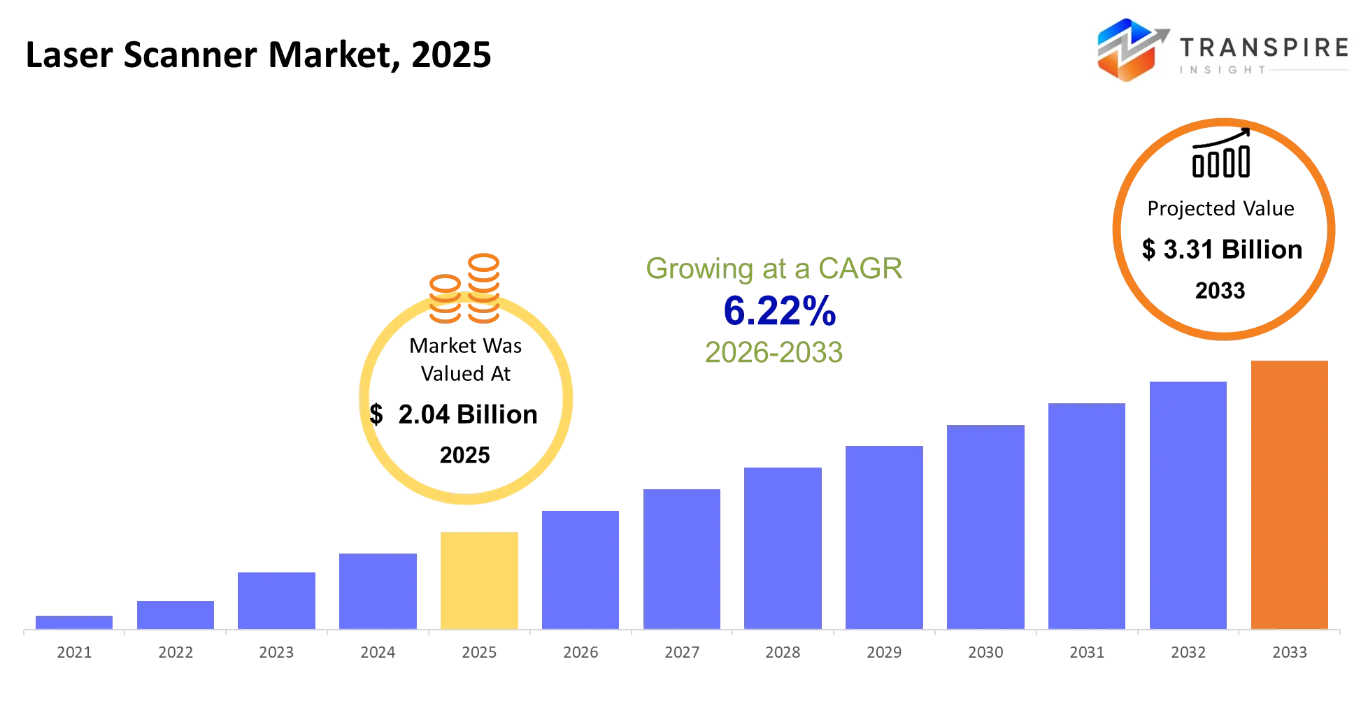
As per Transpire Insight Analysis, the Laser Scanner Market size is estimated at USD 2.04 billion in 2025 and is anticipated to reach USD 3.31 billion by 2033, growing at a CAGR of 6.22% from 2026 to 2033.
The laser scanner market is changing from measurement instruments to reality capture workflows that are adopted in the construction industry, manufacturing industry, surveying, infrastructural development and other technical sectors. I have witnessed how in the past few years innovations in 3D scanning, mobile scanning, cloud processing, and automatic registration technologies have facilitated the conversion of the physical environment to usable digital information. The significant transformation that has occurred is that the laser scanning industry has evolved from being an instrument to becoming part of integrated platforms for capturing and processing data using collaboration tools and digital twin applications. It was due to labour shortages and the necessity of performing inspections and surveys within less site visits that led companies to utilize fast laser scanner techniques. This can be identified through solutions where laser scanners have been combined with real-time processing, automated workflow, and artificial intelligence-based data processing. With the easy operation of laser scanners and their integration with the downstream software, laser scanner adoption has increased among non-survey experts.
Laser Scanner Market Size & Forecast:
- Market Size 2025: USD 2.04 Billion
- Expected Market Value (2033): USD 3.31 Billion
- Forecast CAGR (2026–2033): 6.22%
- Leading Region in 2025: Asia-Pacific
- Fastest Growing Region: North America
- Key Company Profiles: Hexagon AB, Trimble Inc., FARO Technologies, Topcon Corporation, RIEGL Laser Measurement Systems, Nikon Metrology, Creaform, Carl Zeiss Optotechnik, Artec 3D, Teledyne Optech, SICK AG, Renishaw, Zoller + Fröhlich, NavVis, GeoSLAM
Key Market Insights:
The market is moving toward 3D reality capture, with 3D scanners being used for the supplied segment mix. There is also a trend toward developing more portable, automatic, and connected 3D scanning devices.
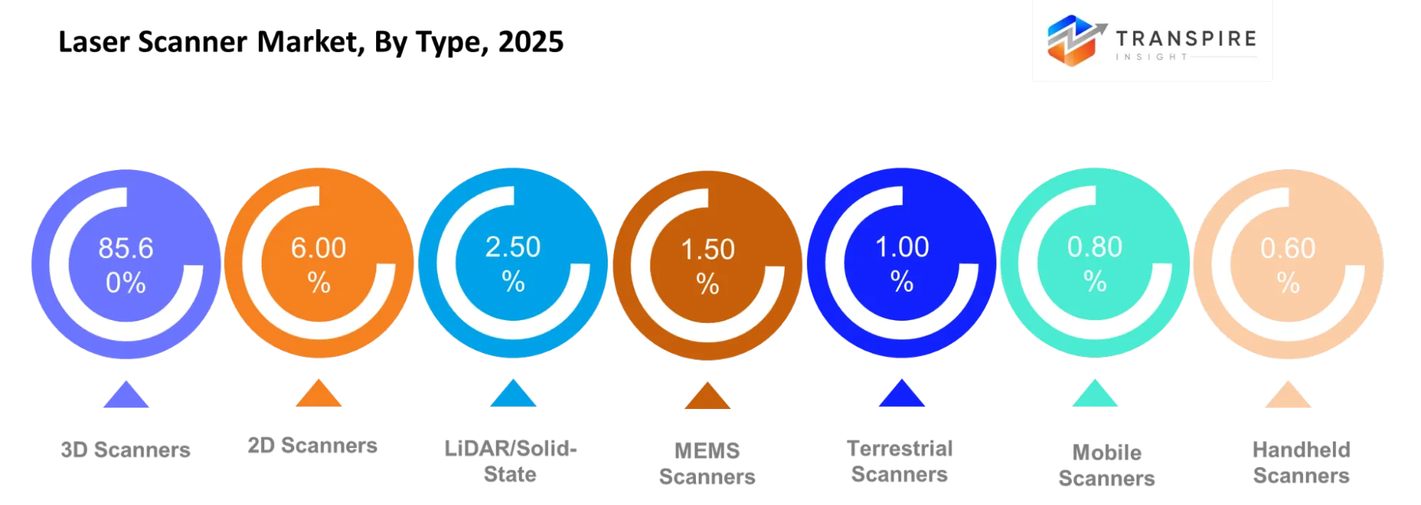
- 3D Scanners account for an 85.60% share, driven by demand for accuracy and digital measurement and modelling capabilities. SHINING 3D offers wireless and integrated scanning solutions in this segment.
- 2D Scanners constitute a 6.00% share, mainly catering to measurement and automation applications. Companies are developing versatile scanning systems now.
- LiDAR and Solid State Scanners make up 2.50% share, with companies developing compact and efficient scanning systems. RIEGL is innovating LiDAR scanning solutions for airborne and 3D mapping applications.
- MEMS Scanners make up 1.50% share, driven by demand for efficient and compact scanning technologies.
- Terrestrial Scanners have a share of 1.00%, catering to surveying and construction applications. Leica Geosystems is developing fast scanning technologies for fast and accurate 3D mapping applications.
- Mobile Scanners account for a 0.80% share, driven by growing demand for portable scanning solutions. ComNav has innovated systems integrating LiDAR, GNSS, camera, and SLAM technologies.
What are the Key Drivers, Restraints, and Opportunities in the Laser Scanner Market?
Drivers
The growth driver is the rising adoption of 3D laser scanning that helps capture precise spatial data without depending on multiple manual measurements. Construction firms, manufacturers, infrastructures, and surveyors are using dense point clouds to conduct inspection, BIM (Building Information Modeling), reverse engineering, and documentation digitally. The driver here is the need to complete more complicated projects within shorter periods by minimizing field trips and manual measurement errors. With the advancement of scanners and their integration with the software being simplified, the business model goes beyond mere scanner sales to include processing, cloud collaboration, digital twin, and inspection services.
Restraints
The high cost of professional scanning technology, along with the expertise needed to process the massive cloud point data sets that come with it. The high-accuracy technology and the processing tools, together with learning the techniques, represent a large investment hurdle for smaller enterprises. This is the result of structural factors, since there is no standard for the accuracy needed across various sectors.
Opportunities
Opportunities in the increasing connectivity and automation of the scanning process. It includes cloud technology solutions, AI-assisted point-cloud analysis, portable scanners, robotics, and even real-time registration. It represents an effort made by the industry to increase accessibility to scanning through easier-to-use equipment. This is demonstrated by the products launched by FARO, Hexagon, Leica Geosystems, and Topcon.
What Has the Impact of artificial intelligence on the Laser Scanner Market?
use of Artificial intelligence in laser scanning makes it possible for organisations to transform their process from data collection in the form of point clouds into data interpretation and automation of decision-making. The use of AI technology can be helpful in object recognition, feature detection, point cloud cleaning, scan registration, classification and identification of abnormal or incomplete data. The advantage of using AI in such a case is that it will enable people working in such environments to save time on repetitive tasks and give them time to analyse the data collected. It can also be used to optimise scanning processes through identifying relevant features, aligning, object recognition, and determining if the data collected is adequate for the particular task. the use of artificial intelligence in this case does not eliminate the need for validation of information collected since the disadvantages include high cost of equipment, requirement of software integration, inconsistencies in the surfaces, reflectivity of objects and the risk of misclassification.
Instance
In April 2026, Hexagon came out with AI-powered FeatureDetect in their Leica Absolute Tracker ATS800 to automatically detect inspection features and shorten the setup process of laser-based quality inspections.https://hexagon.com/company/newsroom/press-releases/2026/hexagon-laser-technologies-help-aerospace-manufacturers-automate-high-mix-large-scale-quality-inspections
Key Market Trends:
The trend is towards the use of connected devices that integrate scan capture, processing, visualization, and collaboration as opposed to the traditional scanning equipment. The product development process is moving towards shorter field times and more usable advanced scanning for different professionals.
- Workflow efficiency is increasing due to improved acquisition speeds and automation of registration.
- Portability and handheldness have become more relevant for users looking for easy-to-move solutions.
- Cloud-enabled scanning is replacing disconnected workflows by letting field and office users access project data early.
- AI functionality is advancing beyond the experimental stage to become relevant for feature detection, point-cloud processing, and automated inspection.
- Construction users are starting to integrate laser scanning with BIM and digital twin workflows for comparisons of existing project conditions with designed ones.
- In manufacturing, integration of scanning data with CAD models and production requirements in automated inspection is taking off.
- Mobile and vehicle-based scanning is increasing coverage areas without having to rely only on stationary scanners.
Laser Scanner Market Segmentation
By Type
3D Scanners have the highest market share of 85.60%, and this signifies that there is a demand for highly accurate three-dimensional capturing and scanning systems used in the construction industry, manufacturing, surveying, inspection, and digital reality applications. 2D Scanners account for 6.00%, LiDAR/Solid-State accounts for 2.50%, MEMS Scanners for 1.50%, Terrestrial Scanners for 1.00%, Mobile Scanners for 0.80%, Handheld Scanners for 0.60%, and other technologies for 2.00%. The trend in the future in the type segment would be towards scanners that are accurate and portable.
By Range-wise
Short-range sensors are designed for applications where precision measuring is desired within limited space, whereas mid-range and long-range sensors can be used for construction, infrastructure, industries, and survey work. Ultra-long-range sensors are suitable for difficult outdoor conditions and large measuring areas. Indoor sensors work in indoor conditions, whereas outdoor sensors are used in outdoor environments and mixed-range sensors are flexible enough to be used in any of these project scenarios. Future improvement will revolve around range extension without compromising on measuring accuracy and speed.
By Technology
Time-of-Flight sensors are still important in long distance measuring, whereas Phase Shift sensors are appropriate for fast and precise scanning in favorable conditions. Triangulation and Structured light sensors are used in high precision measurement where needed in industries and other controlled environments. Solid State LiDAR, MEMS LiDAR and Flash LiDAR sensors are helpful in making the next step towards electronic integration of sensors. Future scope will be around accuracy, speed, hardware reduction and intelligent software processing of data.
By Deployment
The Stationary/Terrestrial type is used to perform the process of site documentation, surveying, construction, and industrial measuring. The use of Hand-Held scanners allows obtaining results when it is necessary to capture small and complicated objects, whereas, the use of Mobile vehicle-mounted and Drone-mounted scanners allows performing the process of scanning the bigger and hard-to-reach areas. In addition, the use of robots becomes increasingly important since scanner manufacturers integrate scanning devices into autonomous inspection and mapping platforms. It means that the deployment segment evolves towards more flexible capturing methods, reducing setup time and improving access to complex environments.
By Verticals
The automotive & transportation, aerospace & defence, building/construction & BIM, industrial manufacturing & automation, oil/gas & mining, healthcare & life sciences, cultural heritage & archaeology, government/survey & mapping industries have different scanning needs. Among all other segments, cultural heritage & archaeology becomes the leader in terms of growth with an 8.55% CAGR driven by digital preservation and site documentation processes. The construction industry also obtains benefits due to the implementation of scan-to-model workflow. In addition, the manufacturing industry applies scanning for inspection and reverse engineering.
By Applications
The field of metrology will still require scan data for measuring things with great accuracy. The field of Digital Twins and Building Information Modelling will increasingly incorporate scan data in planning, design, construction, and facilities management. Surveying and Mapping will still require scanners in documenting space, while Robotics Navigation will benefit from LiDAR sensors and similar scanning systems. In inspection and quality control, scan data will be used to document discrepancies in dimensions and problems in manufacturing processes. In asset management, scan data will be applied in documenting infrastructure and facilities.
What are the Key Use Cases Driving the Laser Scanner Market?
The leading 3D Scanner market segment is associated with the field of reality capture for construction, surveying, BIM, industrial metrology, and inspection. Point cloud data helps project teams to document the current state and compare real-life objects with engineering drawings, minimising the need for repeated measurements. Among new use cases are quality assurance, reverse engineering, asset documentation, digital twins, infrastructure inspection, and facility management. Portability provided by mobile and handheld scanners makes such workflows increasingly feasible in situations requiring frequent movement or restricted access. Some novel applications are being developed in the fields of robotics, autonomous mapping, drone scanning, heritage conservation, and AI-enabled point cloud processing. Such applications have the potential to add value to scanning through the conversion of spatial data into actionable information.
|
Report Metrics |
Details |
|
Market size value in 2025 |
USD 2.04 Billion |
|
Market size value in 2026 |
USD 2.17 Billion |
|
Revenue forecast in 2033 |
USD 3.31 Billion |
|
Growth rate |
CAGR of 6.22% from 2026 to 2033 |
|
Base year |
2025 |
|
Historical data |
2021 - 2024 |
|
Forecast period |
2026 - 2033 |
|
Report coverage |
Revenue forecast, competitive landscape, growth factors, and trends |
|
Regional scope |
United States; Canada; Mexico; United Kingdom; Germany; France; Italy; Spain; Denmark; Sweden; Norway; China; Japan; India; Australia; South Korea; Thailand; Brazil; Argentina; South Africa; Saudi Arabia; United Arab Emirates |
|
Key company profiled |
Hexagon AB, Trimble Inc., FARO Technologies, Topcon Corporation, RIEGL Laser Measurement Systems, Nikon Metrology, Creaform, Carl Zeiss Optotechnik, Artec 3D, Teledyne Optech, SICK AG, Renishaw, Zoller + Fröhlich, NavVis, GeoSLAM |
|
Customization scope |
Free report customization (country, regional & segment scope). Avail customized purchase options to meet your exact research needs. |
|
Report Segmentation |
Type (2D Scanners, 3D Scanners, LiDAR Scanners, Solid-State Scanners, MEMS Scanners, Terrestrial Scanners, Mobile Scanners, Others); Range (Short-Range, Mid-Range, Long-Range, Ultra-Long-Range, Indoor, Outdoor, Mixed-Range, Others); Technology (Time-of-Flight, Phase-Shift, Triangulation, Structured-Light, Solid-State LiDAR, MEMS LiDAR, Flash LiDAR, Others); Deployment (Stationary/Terrestrial, Hand-Held, Mobile Vehicle-Mounted, Drone-Mounted, Robotic, Wearable, Portable, Others); Vertical (Automotive & Transportation, Aerospace & Defence, Building/Construction & BIM, Industrial Manufacturing & Automation, Oil/Gas & Mining, Healthcare & Life Sciences, Cultural Heritage & Archaeology, Government/Survey & Mapping); Application (Metrology, Digital Twins, BIM, Surveying & Mapping, Robotics Navigation, Inspection & Quality Control, Asset Management, Others) |
Which Regions are Driving the Laser Scanner Market Growth?
North America
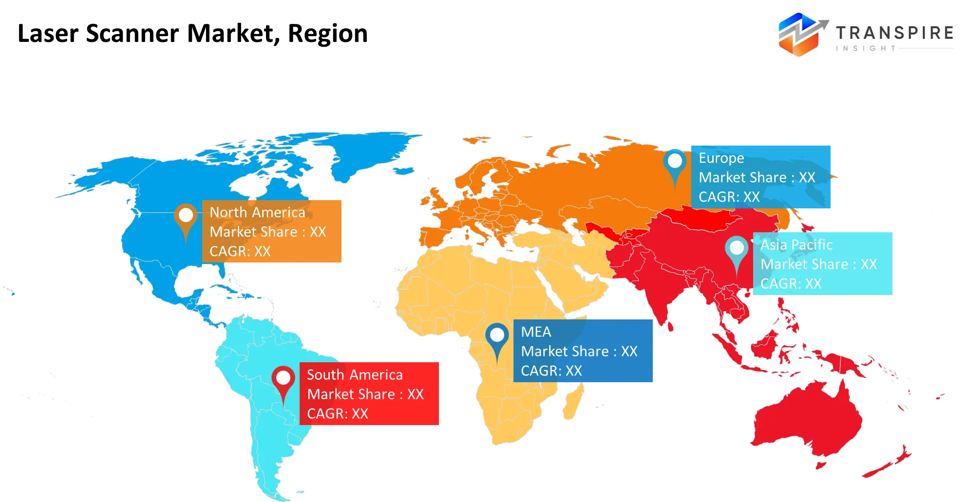
North America constitutes 27.00% of the supplied regional market and is noted as the fastest-growing region at 7.2% CAGR. This growth is facilitated by advanced manufacturing, adoption of construction technology, infrastructure developments, and automation of inspections and measurements. Additionally, this region is experiencing increased utilisation of scanning with robots, artificial intelligence, BIM, and digitalisation.
In July 2025, Dusty Robotics unveiled its support for Hexagon’s Leica Absolute Tracker AT500, combining laser-based measurements with its FieldPrinter 2 construction robot to enhance construction layout and accuracy. This marks an increased adoption of laser-based measurement systems in combination with robotics within North American construction applications.https://hexagon.com/company/newsroom/press-releases/2025/dusty-robotics-announces-support-for-leica-absolute-tracker-at500-by-hexagon
Europe
Europe comprises 25.00% of the supplied regional market and comes close behind North America with regard to its market share. Stability in its market is due to the presence of mature engineering sectors, industrial automation, surveys, and the need for precise digital documentation. Furthermore, there is the presence of mature measurement and geospatial technologies in this region.
In April 2025, Topcon Positioning Systems showcased its CR-P1 3D laser scanner as well as upgraded Collage Site software at Bauma 2025 held in Munich, Germany. The system allows for real-time data acquisition, processing, and viewing of georeferenced point clouds for construction, surveying, and digital reality applications within Europe.https://www.topconpositioning.com/articles/topcon-introduces-solutions-for-3d-mass-data-workflows
Asia-Pacific
Asia-Pacific constitutes the highest share in terms of regional share, which is 33.10%. This is because of the rise in industrial growth, construction, infrastructure development, and the implementation of advanced technology in digital measurements. The vast production base in the Asia-Pacific region offers many opportunities in the field of inspections, metrology, automation, and reverse engineering.
In June 2026, Leica Geosystems released the Leica RTC series, including the RTC300, RTC500 and RTC700 terrestrial laser scanners. The new line of scanners features fast data capture, accuracy and real-time collaboration within construction, surveying and infrastructure projects.https://hexagon.com/company/newsroom/press-releases/2026/leica-geosystems-new-leica-rtc-series-sets-the-new-benchmark-in-scanning-accuracy-and-productivity
Who are the Key Players in the Laser Scanner Marketand how do they Compete?
In the laser scanner competition in the international market, companies differentiate by offering faster data collection, portable hardware, automatic registration, processing aided by artificial intelligence, cloud-based collaboration, as well as integration of hardware with BIM, digital twins, inspection, and metrology processes. The competitive structure thus rewards those that offer connectivity between hardware and software, as well as application-specific solutions. Hexagon stresses innovation in surveying, manufacturing, automation, and digital-reality processes. New products from this company highlight a business strategy oriented towards the combination of highly accurate measurement and automation together with smart software.FARO combines product availability with connected reality-capture solutions. The FARO INSIGHT business line has increased the variety of scanners in its portfolio, connecting hardware to such software as Stream, Sphere XG, and SCENE. Future developments of the company's 2026 products emphasise portability, processing speeds, workflow integration, and processing assisted by artificial intelligence. Terrestrial scanners and real-time collaboration are the focus for Leica Geosystems, a company belonging to Hexagon, whereas real-time point cloud processing and field productivity are the focus for Topcon.
Laser Scanner Market companies
- Hexagon AB
- Trimble Inc.
- FARO Technologies
- Topcon Corporation
- RIEGL Laser Measurement Systems
- Nikon Metrology
- Creaform
- Carl Zeiss Optotechnik
- Artec 3D
- Teledyne Optech
- SICK AG
- Renishaw
- Zoller + Fröhlich
- NavVis
- GeoSLAM
Recent Development News
In June 2026, Hexagon unveiled the latest line of terrestrial laser scanners from Leica Geosystems - the Leica RTC series. Featuring faster scanning capabilities, increased precision, and real-time collaboration via Livelink, the RTC300, RTC500, and RTC700 allow users to pinpoint data voids even before leaving the project location and cut down the time needed for rework.
In October 2025, the first handheld 3D laser scanner from Hexagon – the ATLASCAN Pro – came out. This portable wireless device offers fast 3D scanning with scan-to-CAD capabilities.
What Strategic Insights Define the Future of the Laser Scanner Market?
The future trend for the laser scanner market is towards reality-capture ecosystems that incorporate scanners rather than scanners alone. The key strategic trend is linking scanners to cloud-based systems, artificial intelligence (AI)-enabled processing, Building Information Modelling (BIM), digital twins, robotic applications, and collaboration. There is also a subtle threat of hardware improvements outpacing customer capabilities to integrate point cloud data within legacy software and workflows, thus hampering adoption even while scanner capabilities improve. A promising opportunity is the creation of easy-to-use workflows for professional scanning that would include point cloud registration automation, mobile hardware and smart data processing. From the standpoint of strategy, the market players need to be working on comprehensive capture-to-insight solutions, software and cloud services, application-oriented workflows, and reducing the difficulties of integration.
Type
- 2D Scanners
- 3D Scanners
- LiDAR Scanners
- Solid-State Scanners
- MEMS Scanners
- Terrestrial Scanners
- Mobile Scanners
- Others
Range
- Short-Range
- Mid-Range
- Long-Range
- Ultra-Long-Range
- Indoor
- Outdoor
- Mixed-Range
- Others
Technology
- Time-of-Flight
- Phase-Shift
- Triangulation
- Structured-Light
- Solid-State LiDAR
- MEMS LiDAR
- Flash LiDAR
- Others
Deployment
- Stationary/Terrestrial
- Hand-Held
- Mobile Vehicle-Mounted
- Drone-Mounted
- Robotic
- Wearable
- Portable
- Others
Vertical
- Automotive & Transportation
- Aerospace & Defence
- Building/Construction & BIM
- Industrial Manufacturing & Automation
- Oil/Gas & Mining
- Healthcare & Life Sciences
- Cultural Heritage & Archaeology
- Government/Survey & Mapping
Application
- Metrology
- Digital Twins
- BIM
- Surveying & Mapping
- Robotics Navigation
- Inspection & Quality Control
- Asset Management
- Others
By Regional Analysis
North America
- US
- Canada
- Mexico
Europe
- Germany
- UK
- France
- Italy
- Spain
- Russia
- Rest of Europe
Asia Pacific
- China
- Japan
- India
- South Korea
- Australia
- Rest of Asia Pacific
South America
- Brazil
- Argentina
- Rest of South America
Middle East & Africa
- UAE
- Saudi Arabia
- Qatar
- South Africa
- Rest of the Middle East & Africa
Frequently Asked Questions
Find quick answers to common questions.
The laser scanner market size was valued at USD 2.04 Billion in 2025 and is poised to reach USD 3.31 Billion by 2033, expanding at a 6.22% CAGR.
Key segments for the laser scanner market are Type (2D Scanners, 3D Scanners, LiDAR Scanners, Solid-State Scanners, MEMS Scanners, Terrestrial Scanners, Mobile Scanners, Others); Range (Short-Range, Mid-Range, Long-Range, Ultra-Long-Range, Indoor, Outdoor, Mixed-Range, Others); Technology (Time-of-Flight, Phase-Shift, Triangulation, Structured-Light, Solid-State LiDAR, MEMS LiDAR, Flash LiDAR, Others); Deployment (Stationary/Terrestrial, Hand-Held, Mobile Vehicle-Mounted, Drone-Mounted, Robotic, Wearable, Portable, Others); Vertical (Automotive & Transportation, Aerospace & Defence, Building/Construction & BIM, Industrial Manufacturing & Automation, Oil/Gas & Mining, Healthcare & Life Sciences, Cultural Heritage & Archaeology, Government/Survey & Mapping); Application (Metrology, Digital Twins, BIM, Surveying & Mapping, Robotics Navigation, Inspection & Quality Control, Asset Management, Others)
Growth is primarily driven by an increase in demand for 3D scanning, automation in manufacturing processes, construction of infrastructure, use of LIDAR, and the requirement for precise measurement and inspection systems.
The market is led by major manufacturers including Hexagon AB, Trimble Inc., FARO Technologies, Topcon Corporation, RIEGL Laser Measurement Systems, Nikon Metrology, Creaform, Carl Zeiss Optotechnik, Artec 3D, Teledyne Optech, SICK AG, Renishaw, Zoller + Fröhlich, NavVis, GeoSLAM
The Asia-Pacific region accounts for 33.10% of the world laser scanner market due to industrialisation, manufacturing and construction operations, and increased use of automation and 3D scanning.
Opportunities for businesses in the laser scanner market involve increased demand for three-dimensional scanning in construction and infrastructure projects, use of laser scanning for automated inspection and quality control, growing popularity of LiDAR technology, and adoption of laser scanners in robotics and manufacturing industries.
- Hexagon AB
- Trimble Inc.
- FARO Technologies
- Topcon Corporation
- RIEGL Laser Measurement Systems
- Nikon Metrology
- Creaform
- Carl Zeiss Optotechnik
- Artec 3D
- Teledyne Optech
- SICK AG
- Renishaw
- Zoller + Fröhlich
- NavVis
- GeoSLAM
About the Authors

Mayur Shinde
I am Mayur Shinde, a Senior Research Analyst at Transpire Insight, specializing in the Automotive & Transportation and Information & Communication Technology (ICT) Industry. My work focuses on analyzing emerging market trends, technological advancements, competitive landscapes, and industry developments to deliver accurate, data-driven insights. I am passionate about transforming complex market information into clear, actionable content that helps businesses, professionals, and decision-makers stay informed and make confident strategic decisions.

Chakradhar Khansole
Chakradhar serves as the Research Director at Transpire Insight, bringing over 8 years of experience in technology, innovation, and strategic market intelligence. He specializes in transforming complex market data into actionable business insights that enable organizations to make informed, growth-oriented decisions. Recognized for his strategic vision and analytical expertise, Chakradhar leads high-impact research initiatives, delivering comprehensive market assessments, competitive intelligence, and forward-looking industry analysis.
Recently Published Reports
-
Apr 2026
3D Optical Profiler Market
3D Optical Profiler Market Size, Share & Analysis Report By Type (Desktop 3D Optical Profiler, and Portable 3D Optical Profiler), By Technology (Confocal Technology, and White Light Interference), By End-Use Industry (Manufacturing, Research Institutions, Automotive, Aerospace and Defense, Medical Devices, and Other), and Geography (North America, Europe, Asia-Pacific, Middle East and Africa, South and Central America), 2021 - 2031
-
Apr 2026
Depth Sensor Market
Depth Sensor Market Size, Share & Analysis Report By Type (Infrared Depth Sensors, Time-of-Flight (ToF) Sensors, Stereo Vision Sensors, Structured Light Sensors, Ultrasonic Depth Sensors), By Application (Automotive, Robotics, Gaming, Consumer Electronics, Industrial Automation, Healthcare, Security & Surveillance, Others), By End Users (Automotive Manufacturers, Consumer Electronics Companies, Healthcare Providers, Industrial Companies, Security Agencies, Gaming Companies, Robotics Companies, Others), and Geography (North America, Europe, Asia-Pacific, Middle East and Africa, South and Central America), 2021 – 2031
-
Apr 2026
Digital Manufacturing Market
Digital Manufacturing Market Size, Share & Analysis Report By Component (Hardware, Software, and Services), By Technology (Robotics, 3D Printing, Internet of Things (IoT), and Others), By Application (Automotive and Transportation, Aerospace and Defense, Consumer Electronics, Industrial Machinery, and Others), By Process Type (Computer-Based Designing, Computer-Based Simulation, Computer 3D Visualization, Analytics, and Others), and Geography (North America, Europe, Asia-Pacific, Middle East and Africa, South and Central America), 2021 – 2031
-
Apr 2026
Digital Visa Services Market
Digital Visa Services Market Size, Share & Analysis Report By Type (Individual Travelers, Group Travelers), By Application (Tourism, Business Travel, Others), and Geography (North America, Europe, Asia-Pacific, Middle East and Africa, South and Central America), 2021 – 2031